
Lancaster topographic map
Click on the map to display elevation.
About this map
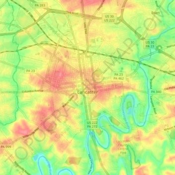
Name: Lancaster topographic map, elevation, terrain.
Location: Lancaster, Lancaster County, Pennsylvania, United States (40.00658 -76.34605 40.07295 -76.25404)
Average elevation: 102 m
Minimum elevation: 65 m
Maximum elevation: 135 m
Other topographic maps
Click on a map to view its topography, its elevation and its terrain.
Reinholds
United States > Pennsylvania > Lancaster County > West Cocalico Township
Average elevation: 159 m
Welsh Mountain Nature Preserve
United States > Pennsylvania > Lancaster County > East Earl Township
Average elevation: 294 m
Intercourse
United States > Pennsylvania > Lancaster County > Leacock Township
Average elevation: 127 m
Holland Heights
United States > Pennsylvania > Lancaster County > East Lampeter Township
Average elevation: 101 m
Kissel Hill
United States > Pennsylvania > Lancaster County > Warwick Township
Average elevation: 126 m
Brownstown
United States > Pennsylvania > Lancaster County > West Earl Township
Average elevation: 102 m
Stevens
United States > Pennsylvania > Lancaster County > West Cocalico Township
Average elevation: 121 m
Smithville
United States > Pennsylvania > Lancaster County > Providence Township
Average elevation: 140 m
Drumore Center
United States > Pennsylvania > Lancaster County > Drumore Township
Average elevation: 175 m
Ironville
United States > Pennsylvania > Lancaster County > West Hempfield Township
Average elevation: 141 m
Landisville
United States > Pennsylvania > Lancaster County > East Hempfield Township
Average elevation: 122 m
Centerville
United States > Pennsylvania > Lancaster County > East Hempfield Township > Rohrerstown
Average elevation: 135 m
Rheems
United States > Pennsylvania > Lancaster County > West Donegal Township
Average elevation: 134 m
Landisville
United States > Pennsylvania > Lancaster County > East Hempfield Township
Average elevation: 122 m
Hopeland
United States > Pennsylvania > Lancaster County > Clay Township > Clay
Average elevation: 155 m
Baumgardner
United States > Pennsylvania > Lancaster County > Pequea Township
Average elevation: 126 m
Chestnut Ridge
United States > Pennsylvania > Lancaster County > Rohrerstown > Chestnut Ridge
Average elevation: 122 m
Churchtown
United States > Pennsylvania > Lancaster County > Caernarvon Township
Average elevation: 163 m
Safe Harbor
United States > Pennsylvania > Lancaster County > Conestoga Township
Average elevation: 103 m
Stevens
United States > Pennsylvania > Lancaster County > West Cocalico Township
Average elevation: 121 m
Welsh Mountain
United States > Pennsylvania > Lancaster County > Caernarvon Township
Average elevation: 233 m
Coopersville
United States > Pennsylvania > Lancaster County > Sadsbury Township
Average elevation: 183 m
Greenland
United States > Pennsylvania > Lancaster County > East Lampeter Township
Average elevation: 112 m
Farmdale
United States > Pennsylvania > Lancaster County > West Hempfield Township
Average elevation: 131 m
McGovernsville
United States > Pennsylvania > Lancaster County > East Hempfield Township > Rohrerstown
Average elevation: 109 m
Brooklawn
United States > Pennsylvania > Lancaster County > Manheim Township > Neffsville
Average elevation: 116 m
Bowling Green
United States > Pennsylvania > Lancaster County > Manor Township
Average elevation: 107 m
Smithville
United States > Pennsylvania > Lancaster County > Providence Township
Average elevation: 140 m
Reinholds
United States > Pennsylvania > Lancaster County > West Cocalico Township
Average elevation: 159 m