
Quảng Nam Province topographic map
Interactive map
Click on the map to display elevation.
About this map
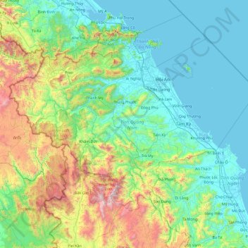
Name: Quảng Nam Province topographic map, elevation, terrain.
Location: Quảng Nam Province, Vietnam (14.95135 107.21092 16.16632 109.02356)
Average elevation: 464 m
Minimum elevation: -2 m
Maximum elevation: 2,536 m
Quảng Nam comprises flat land along the coast and increasingly high elevations towards the west, with the highest elevations along the border to Laos and Kon Tum province. The highest peak is Ngọc Linh mountain at 2598m. In contrast to the other provinces of the South Central Coast there are no hills or mountains near the coast (with the exception of the Chàm Islands with a peak of 517m).
Other topographic maps
Click on a map to view its topography, its elevation and its terrain.
Nhơn Trạch District
Nhơn Trạch District, Đồng Nai Province, Vietnam
Average elevation: 6 m
Xã Đất Mũi
Vietnam > Ca Mau province > Ngọc Hiển District
Xã Đất Mũi, Ngọc Hiển District, Cà Mau Province, Vietnam
Average elevation: 0 m
Thai Nguyen City
Vietnam > Thai Nguyen province
Thai Nguyen City, Thai Nguyen province, 20000, Vietnam
Average elevation: 40 m
Ha Giang
Vietnam > Hà Giang Province > Hà Giang > Ha Giang
Ha Giang, Hà Giang, Hà Giang Province, 0219, Vietnam
Average elevation: 608 m
Lục Ngạn District
Lục Ngạn District, Bac Giang Province, 230000, Vietnam
Average elevation: 154 m
Ward 11
Vietnam > Ho Chi Minh City > Ward 11
Ward 11, Binh Thanh District, Ho Chi Minh City, Vietnam
Average elevation: 10 m
Ho Chi Minh City
Vietnam > Ho Chi Minh City > Ho Chi Minh City
Ho Chi Minh City, District 1, Ho Chi Minh City, 00084, Vietnam
Average elevation: 6 m
Ngoc Hien District
Ngoc Hien District, Ca Mau province, Vietnam
Average elevation: 1 m
Black River
Black River, Mường La District, Son La province, 02103, Vietnam
Average elevation: 786 m