
Lào Cai Province topographic map
Interactive map
Click on the map to display elevation.
About this map
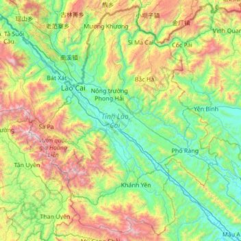
Name: Lào Cai Province topographic map, elevation, terrain.
Location: Lào Cai Province, Vietnam (21.87581 103.52943 22.84492 104.62866)
Average elevation: 791 m
Minimum elevation: 39 m
Maximum elevation: 3,060 m
There are ten major soil groups under 30 categories in the province, under ten land groups. The land groups are: The Alluvial group (1.47% of the land area) along the Red River is good for growing food crops and trees; the Oxisol type which occupies 40% of land area has generally reddish brown soil, below altitude of 900 metres (3,000 ft), is a fertile land suitable for the annual and commercial crops; Team Red Yellow soil humus covers 30% land area in the Sa Pa, Mường Khương, Bắc Hà, Bát Xát districts of the province suitable for medicinal plants, fruit trees and vegetables; humus soil on the mountain occupies 11.42% of the land area mostly in Sa Pa district which has rich canopy of mixed forest; and the Oxisol color altered by rice in 2% of land area are formed into a landscape of terraced fields, as seen in Bắc Hà and Sa Pa districts.
Other topographic maps
Click on a map to view its topography, its elevation and its terrain.
Nhơn Trạch District
Nhơn Trạch District, Đồng Nai Province, Vietnam
Average elevation: 6 m
Xã Đất Mũi
Vietnam > Ca Mau province > Ngọc Hiển District
Xã Đất Mũi, Ngọc Hiển District, Cà Mau Province, Vietnam
Average elevation: 0 m
Thai Nguyen City
Vietnam > Thai Nguyen province
Thai Nguyen City, Thai Nguyen province, 20000, Vietnam
Average elevation: 40 m
Ha Giang
Vietnam > Hà Giang Province > Hà Giang > Ha Giang
Ha Giang, Hà Giang, Hà Giang Province, 0219, Vietnam
Average elevation: 608 m
Lục Ngạn District
Lục Ngạn District, Bac Giang Province, 230000, Vietnam
Average elevation: 154 m
Ward 11
Vietnam > Ho Chi Minh City > Ward 11
Ward 11, Binh Thanh District, Ho Chi Minh City, Vietnam
Average elevation: 10 m
Ho Chi Minh City
Vietnam > Ho Chi Minh City > Ho Chi Minh City
Ho Chi Minh City, District 1, Ho Chi Minh City, 00084, Vietnam
Average elevation: 6 m
Ngoc Hien District
Ngoc Hien District, Ca Mau province, Vietnam
Average elevation: 1 m
Black River
Black River, Mường La District, Son La province, 02103, Vietnam
Average elevation: 786 m