
Selçuk topographic map
Interactive map
Click on the map to display elevation.
About this map
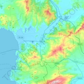
Name: Selçuk topographic map, elevation, terrain.
Location: Selçuk, Izmir, Aegean Region, Turkey (37.81523 27.24531 38.08134 27.50205)
Average elevation: 178 m
Minimum elevation: -2 m
Maximum elevation: 1,006 m
Other topographic maps
Click on a map to view its topography, its elevation and its terrain.
Valens Aqueduct
The water comes from two lines from the north-east and one coming from the north-west, which join together outside the walls, near the Adrianople Gate (Edirne Kapı). Near the east end of the aqueduct there is a distribution plant, and another lies near Hagia Sophia. The water feeds the zone of the imperial…
Average elevation: 33 m
Gençlik Parkı
The 27.5 ha (68 acres) park is almost at the center of Ankara. Its altitude is about 850 m (2,790 ft), which makes it one of the lowest points in Ankara. It is surrounded by Ulus Square to the north, the Ankara Opera House (formerly Ankara Exhibition Building) to the east, Selim Sırrı Tarcan Sport Hall and…
Average elevation: 870 m
Ankara
Ankara has a cold semi-arid climate (Köppen climate classification: BSk). Under the Trewartha climate classification, Ankara has a temperate humid continental climate (Dc). Due to its elevation and inland location, Ankara has cold and snowy winters, and hot and dry summers. Rainfall occurs mostly during the…
Average elevation: 1,082 m
Kahramanmaraş
At 2,300 m (7,500 ft) elevation, the nearby Yedikuyular Ski Resort offers winter sports activities.
Average elevation: 843 m
Kayseri
Kayseri sits at the foot of Mount Erciyes (Turkish: Erciyes Dağı), a dormant volcano that reaches an altitude of 3,916 metres (12,848 feet), more than 1,500 metres above the city's mean altitude. It contains a number of historic monuments, particularly from the Seljuk period. Tourists often pass through…
Average elevation: 1,345 m
Adana
Heading west across Cilicia from Adana, the path to Tarsus crosses the foothills of the Taurus Mountains, eventually reaching an altitude of nearly 1,200 metres (4,000 ft) while passing through the Cilician Gates (Turkish: Gülek Boğazı), a rocky mountain pass functioning as the main artery to the Turkish…
Average elevation: 61 m
Şanlıurfa
An important consideration in domestic architecture is mahremiyat, which could roughly be translated into English as "privacy" or "intimacy" but which carries stronger implications. This concept is especially important when it comes to relations between men and women – outside the extended family,…
Average elevation: 623 m
Karabük
Turkey > Karabük Merkez > Karabük
Karabük is a town and the capital district of Karabük Province in the Black Sea region of Turkey. According to the 2009 census, population of the city is 108 167. The district covers an area of 760 km2 (293 sq mi), and the town lies at an elevation of 354 m (1,161 ft).
Average elevation: 864 m