Geolocate

Ordu topographic map

Click on the map to display elevation.

About this map

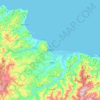
Name: Ordu topographic map, elevation, terrain.

Location: Ordu, Altınordu, Ordu, Black Sea Region, 52100, Turkey (40.82523 37.71977 41.14523 38.03977)

Average elevation: 239 m

Minimum elevation: 0 m

Maximum elevation: 1,264 m

Gear up for your next adventure:

🔗Locking Carabiners - Secure gear to your pack or for light climbing
🎒Day Packs - Perfect packs for day trips
🥾Women's Waterproof Boots - Gore-Tex protection for trail and mountain walking
🧤Thermal Outdoor Gloves - Windproof and waterproof gloves for winter hiking
🛌Cold Weather Sleeping Bags - Warm sleeping bags for colder hikes

As an Amazon Associate, this site earns from qualifying purchases at no extra cost to you.