
Thank you for supporting this site ❤️
Make a donation
Make a donation
Gear up for your next adventure:
As an Amazon Associate, this site earns from qualifying purchases at no extra cost to you.
Izmir topographic map
Click on the map to display elevation.
Thank you for supporting this site ❤️
Make a donation
Make a donation
Gear up for your next adventure:
As an Amazon Associate, this site earns from qualifying purchases at no extra cost to you.
About this map
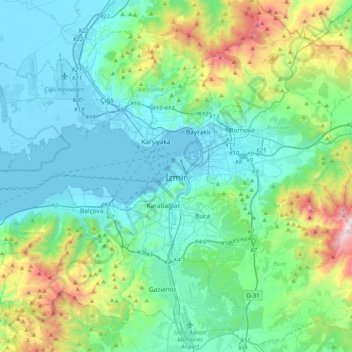
Name: Izmir topographic map, elevation, terrain.
Location: Izmir, Konak, Izmir, Aegean Region, 35240, Turkey (38.26374 26.98280 38.58374 27.30280)
Average elevation: 279 m
Minimum elevation: -4 m
Maximum elevation: 1,397 m
Thank you for supporting this site ❤️
Make a donation
Make a donation
Gear up for your next adventure:
As an Amazon Associate, this site earns from qualifying purchases at no extra cost to you.