
Make a donation
Gear up for your next adventure:
As an Amazon Associate, this site earns from qualifying purchases at no extra cost to you.
Kleopatra Koyu topographic map
Click on the map to display elevation.
Make a donation
Gear up for your next adventure:
As an Amazon Associate, this site earns from qualifying purchases at no extra cost to you.
About this map
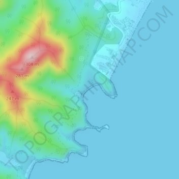
Name: Kleopatra Koyu topographic map, elevation, terrain.
Location: Kleopatra Koyu, Mediterranean Region, 07995, Turkey (36.48005 30.51756 36.48015 30.51766)
Average elevation: 51 m
Minimum elevation: -2 m
Maximum elevation: 302 m
Make a donation
Gear up for your next adventure:
As an Amazon Associate, this site earns from qualifying purchases at no extra cost to you.
Other topographic maps
Click on a map to view its topography, its elevation and its terrain.
Make a donation
Gear up for your next adventure:
As an Amazon Associate, this site earns from qualifying purchases at no extra cost to you.
Valens Aqueduct
The water comes from two lines from the north-east and one coming from the north-west, which join together outside the walls, near the Adrianople Gate (Edirne Kapı). Near the east end of the aqueduct there is a distribution plant, and another lies near Hagia Sophia. The water feeds the zone of the imperial…
Average elevation: 33 m
Make a donation
Gear up for your next adventure:
As an Amazon Associate, this site earns from qualifying purchases at no extra cost to you.
Make a donation
Gear up for your next adventure:
As an Amazon Associate, this site earns from qualifying purchases at no extra cost to you.
Make a donation
Gear up for your next adventure:
As an Amazon Associate, this site earns from qualifying purchases at no extra cost to you.
Make a donation
Gear up for your next adventure:
As an Amazon Associate, this site earns from qualifying purchases at no extra cost to you.
Gençlik Parkı
The 27.5 ha (68 acres) park is almost at the center of Ankara. Its altitude is about 850 m (2,790 ft), which makes it one of the lowest points in Ankara. It is surrounded by Ulus Square to the north, the Ankara Opera House (formerly Ankara Exhibition Building) to the east, Selim Sırrı Tarcan Sport Hall and…
Average elevation: 870 m
Kırşehir
Kırşehir Province (Turkish: Kırşehir ili) is a province in central Turkey, forming part of the Central Anatolia Region. Its area is 6,584 km2, and its population is 244,519 (2022). The average elevation is approximately 985 meters above sea level. The provincial capital is Kırşehir. The geographical…
Average elevation: 1,079 m
Make a donation
Gear up for your next adventure:
As an Amazon Associate, this site earns from qualifying purchases at no extra cost to you.
Bağcılar
Bağcılar is located on the European side of Istanbul, within the service boundaries of Istanbul Metropolitan Municipality. Its area is 22 km2 (8.5 sq mi). The district is now known as an immigrant quarter. It lies between E-5 and TEM. In the south Bahçelievler, in the west Küçükçekmece, in the northwest…
Average elevation: 85 m
Make a donation
Gear up for your next adventure:
As an Amazon Associate, this site earns from qualifying purchases at no extra cost to you.
Make a donation
Gear up for your next adventure:
As an Amazon Associate, this site earns from qualifying purchases at no extra cost to you.
Salihli
The city of Salihli, the seat of the district, is located on İzmir-Ankara (E 96) highway and the parallel railway connections. The urban zone is situated on the slopes of Bozdağ mountain chain along the southern alluvial plains of the Gediz River. To the north and northeast of the plain extend two other…
Average elevation: 470 m
Make a donation
Gear up for your next adventure:
As an Amazon Associate, this site earns from qualifying purchases at no extra cost to you.
Make a donation
Gear up for your next adventure:
As an Amazon Associate, this site earns from qualifying purchases at no extra cost to you.
Make a donation
Gear up for your next adventure:
As an Amazon Associate, this site earns from qualifying purchases at no extra cost to you.