
Make a donation
Gear up for your next adventure:
As an Amazon Associate, this site earns from qualifying purchases at no extra cost to you.
Golden Horn topographic map
Click on the map to display elevation.
Make a donation
Gear up for your next adventure:
As an Amazon Associate, this site earns from qualifying purchases at no extra cost to you.
About this map
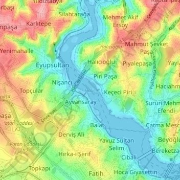
Name: Golden Horn topographic map, elevation, terrain.
Location: Golden Horn, Istanbul, Fatih, Istanbul, Marmara Region, Turkey (41.01759 28.93509 41.06480 28.97511)
Average elevation: 49 m
Minimum elevation: -4 m
Maximum elevation: 124 m
Make a donation
Gear up for your next adventure:
As an Amazon Associate, this site earns from qualifying purchases at no extra cost to you.
Other topographic maps
Click on a map to view its topography, its elevation and its terrain.
Valens Aqueduct
The water comes from two lines from the north-east and one coming from the north-west, which join together outside the walls, near the Adrianople Gate (Edirne Kapı). Near the east end of the aqueduct there is a distribution plant, and another lies near Hagia Sophia. The water feeds the zone of the imperial…
Average elevation: 33 m