
Aleppo Governorate topographic map
Interactive map
Click on the map to display elevation.
About this map
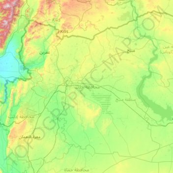
Name: Aleppo Governorate topographic map, elevation, terrain.
Location: Aleppo Governorate, Syria (35.38381 36.54368 36.92412 38.72058)
Average elevation: 439 m
Minimum elevation: 77 m
Maximum elevation: 2,182 m
The average elevation of the terrain is 379 metres (1,243 ft). The surface gradually slopes down in north-south and west-east directions, undulating gently with an amplitude of 10–30 m for each wave. The lowlands are covered with combined Paleozoic and Mesozoic sediments that average 4–5 km in thickness over the whole surface.
Other topographic maps
Click on a map to view its topography, its elevation and its terrain.
Al-Hasakah District
Al-Hasakah District, Al-Hasaka Governorate, Syria
Average elevation: 356 m
Fealat Gharbiyeh Neighborhood
Fealat Gharbiyeh Neighborhood, Al Mazzah Region, Damascus Governorate, Syria
Average elevation: 786 m
Al-Bab
Syria > Aleppo Governorate > Al-Bab
Al-Bab, Al-Bab Subdistrict, al-Bab District, Aleppo Governorate, Syria
Average elevation: 460 m
Al-Tabqah
Syria > Ar-Raqqah Governorate > Al-Tabqah > Al-Tabqah
Al-Tabqah, Al-Thawrah Subdistrict, Al-Thawrah District, Ar-Raqqah Governorate, Syria
Average elevation: 339 m
Damascus
Syria > Damascus Governorate > Amara Jowaniyyeh Neighbourhood
Damascus, Amara Jowaniyyeh Neighbourhood, Ancient City of Damascus ٌRegion, Damascus Governorate, Syria
Average elevation: 828 m
Raqqa
Raqqa, Raqqah Subdistrict, Raqqa District, Ar-Raqqah Governorate, Syria
Average elevation: 287 m