Homs Governorate topographic map
Interactive map
Click on the map to display elevation.
About this map
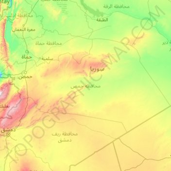
Name: Homs Governorate topographic map, elevation, terrain.
Location: Homs Governorate, Syria (33.55189 36.10542 35.39111 40.16275)
Average elevation: 604 m
Minimum elevation: 95 m
Maximum elevation: 3,015 m
Other topographic maps
Click on a map to view its topography, its elevation and its terrain.
Al-Hasakah District
Al-Hasakah District, Al-Hasaka Governorate, Syria
Average elevation: 356 m
Fealat Gharbiyeh Neighborhood
Fealat Gharbiyeh Neighborhood, Al Mazzah Region, Damascus Governorate, Syria
Average elevation: 786 m
Al-Bab
Syria > Aleppo Governorate > Al-Bab
Al-Bab, Al-Bab Subdistrict, al-Bab District, Aleppo Governorate, Syria
Average elevation: 460 m
Al-Tabqah
Syria > Ar-Raqqah Governorate > Al-Tabqah > Al-Tabqah
Al-Tabqah, Al-Thawrah Subdistrict, Al-Thawrah District, Ar-Raqqah Governorate, Syria
Average elevation: 339 m
Damascus
Syria > Damascus Governorate > Amara Jowaniyyeh Neighbourhood
Damascus, Amara Jowaniyyeh Neighbourhood, Ancient City of Damascus ٌRegion, Damascus Governorate, Syria
Average elevation: 828 m
Raqqa
Raqqa, Raqqah Subdistrict, Raqqa District, Ar-Raqqah Governorate, Syria
Average elevation: 287 m