
Hudson County topographic map
Interactive map
Click on the map to display elevation.
About this map
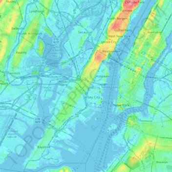
Name: Hudson County topographic map, elevation, terrain.
Location: Hudson County, New Jersey, United States (40.64199 -74.16600 40.82357 -73.98487)
Average elevation: 12 m
Minimum elevation: -9 m
Maximum elevation: 98 m
The topography is marked by the New Jersey Palisades in the north with cliffs overlooking the Hudson to the east and less severe cuesta, or slope, to the west. They gradually level off to the southern peninsula, which is coastal and flat. The western region, around the Hackensack and Passaic is part of the New Jersey Meadowlands. Much of the land along the county's extensive shoreline and littoral zone was created by land reclamation.
Other topographic maps
Click on a map to view its topography, its elevation and its terrain.
Morristown
United States > New Jersey > Morris County
Morristown, Morris County, New Jersey, 07960, United States
Average elevation: 123 m
Trenton
United States > New Jersey > Mercer County
Trenton, Mercer County, New Jersey, United States
Average elevation: 20 m
Island Beach
United States > New Jersey > Ocean County > Berkeley Township
Island Beach, Berkeley Township, Ocean County, New Jersey, United States
Average elevation: 1 m
Sparta Township
United States > New Jersey > Sussex County
Sparta Township, Sussex County, New Jersey, United States
Average elevation: 279 m
Big Thorofare
United States > New Jersey > Ocean County > Little Egg Harbor Township
Big Thorofare, Hickory Island, Little Egg Harbor Township, Ocean County, New Jersey, 08087, United States
Average elevation: 3 m
Erma Park
United States > New Jersey > Cape May County > Lower Township
Erma Park, Lower Township, Cape May County, New Jersey, 08242, United States
Average elevation: 4 m
Runnemede
United States > New Jersey > Camden County > Runnemede
Runnemede, Camden County, New Jersey, 08078, United States
Average elevation: 16 m
Elizabeth
United States > New Jersey > Union County > Elizabeth
Elizabeth, Union County, New Jersey, 07202, United States
Average elevation: 32 m
Milltown
United States > New Jersey > Middlesex County
Milltown, Middlesex County, New Jersey, United States
Average elevation: 22 m
Cookstown
United States > New Jersey > Cookstown
Cookstown, Burlington County, New Jersey, 08511, United States
Average elevation: 32 m
Golf View
United States > New Jersey > Golf View
Golf View, Salem County, New Jersey, 08069, United States
Average elevation: 4 m
Deepwater
United States > New Jersey > Deepwater
Deepwater, Salem County, New Jersey, 08023, United States
Average elevation: 3 m