
Sint Eustatius topographic map
Interactive map
Click on the map to display elevation.
About this map
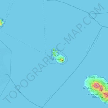
Name: Sint Eustatius topographic map, elevation, terrain.
Location: Sint Eustatius, Netherlands (17.27673 -63.19861 17.72699 -62.78471)
Average elevation: 12 m
Minimum elevation: 0 m
Maximum elevation: 1,044 m
Sint Eustatius is 6 miles (10 km) long and up to 3 miles (5 km) wide. Topographically, the island is saddle-shaped, with the 602-meter-high dormant volcano Quill (Mount Mazinga), (from Dutch kuil, meaning 'pit'—originally referring to its crater) to the southeast and the smaller summits of Signal Hill/Little Mountain (or Bergje) and Boven Mountain to the northwest. The Quill crater is a popular tourist attraction on the island. The bulk of the island's population lives in the flat saddle between the two elevated areas, which forms the centre of the island.
Other topographic maps
Click on a map to view its topography, its elevation and its terrain.
Vlijmen
Vlijmen, Heusden, North Brabant, Netherlands
Average elevation: 4 m
RCN Zeewolde
RCN Zeewolde, Zeewolde, Flevoland, Netherlands, 3896 LT, Netherlands
Average elevation: 0 m
's-Hertogenbosch
's-Hertogenbosch, North Brabant, Netherlands
Average elevation: 4 m
Volendam
Volendam, Edam-Volendam, North Holland, Netherlands
Average elevation: 0 m
Rozendaal
Netherlands > Gelderland > Rozendaal
Rozendaal, Gelderland, Netherlands
Average elevation: 66 m
Zoetermeer
Netherlands > South Holland > Zoetermeer
Zoetermeer, South Holland, Netherlands
Average elevation: -3 m
Winssen
Netherlands > Gelderland > Beuningen
Winssen, Beuningen, Gelderland, Netherlands
Average elevation: 9 m
Oud Ade
Oud Ade, Kaag en Braassem, South Holland, Netherlands
Average elevation: -2 m
Badhoevedorp
Badhoevedorp, Haarlemmermeer, North Holland, Netherlands
Average elevation: -2 m
Kommerdijk
Netherlands > Gelderland > Gendt
Kommerdijk, Gendt, Lingewaard, Gelderland, Netherlands, 6691 MJ, Netherlands
Average elevation: 11 m
Berkelaar
Netherlands > Limburg > Echt
Berkelaar, Echt, Echt-Susteren, Limburg, Netherlands, 6101 XV, Netherlands
Average elevation: 27 m
Culemborg
Netherlands > Gelderland > Culemborg
Culemborg, Gelderland, Netherlands
Average elevation: 2 m
Tilburg
Netherlands > North Brabant > Tilburg
Tilburg, North Brabant, Netherlands
Average elevation: 13 m
Halfweg
Netherlands > North Holland > Halfweg
Halfweg, Haarlemmermeer, North Holland, Netherlands
Average elevation: 0 m
Schiphol
Schiphol, Haarlemmermeer, North Holland, Netherlands
Average elevation: -2 m
Cortenoever
Netherlands > Gelderland > Brummen > Cortenoever
Cortenoever, Brummen, Gelderland, Netherlands, 6971, Netherlands
Average elevation: 9 m
's-Hertogenbosch
Netherlands > North Brabant > 's-Hertogenbosch
's-Hertogenbosch, North Brabant, Netherlands, 5211JS, Netherlands
Average elevation: 7 m
Zaandam
Netherlands > North Holland > Zaandam
Zaandam, Zaanstad, North Holland, Netherlands
Average elevation: 0 m
Sint Pancras
Netherlands > North Holland > Sint Pancras
Sint Pancras, Langedijk, North Holland, Netherlands
Average elevation: 1 m
Hunebed D7 Boswachterij Schipborg
Netherlands > Drenthe > Schipborg
Hunebed D7 Boswachterij Schipborg, Schipborgerweg, Schipborg, Aa en Hunze, Drenthe, Netherlands, 9469TD, Netherlands
Average elevation: 9 m
Hunebed D2 Westervelde
Netherlands > Drenthe > Westervelde
Hunebed D2 Westervelde, Hoofdweg, Westervelde, Noordenveld, Drenthe, Netherlands, 9337 PA, Netherlands
Average elevation: 10 m
Mheer
Netherlands > Limburg > Mheer
Mheer, Eijsden-Margraten, Limburg, Netherlands
Average elevation: 155 m
Westervoort
Netherlands > Gelderland > Westervoort
Westervoort, Gelderland, Netherlands
Average elevation: 11 m
Eindhoven
Netherlands > North Brabant > Eindhoven
Eindhoven, North Brabant, Netherlands
Average elevation: 20 m
Goeree-Overflakkee
Goeree-Overflakkee, South Holland, Netherlands
Average elevation: 0 m
Heerenveen
Netherlands > Friesland > Heerenveen
Heerenveen, Friesland, Netherlands
Average elevation: 1 m
Bonaire
Netherlands > Caribbean Netherlands > Bonaire
Bonaire, Caribbean Netherlands, Netherlands
Average elevation: 1 m