
Make a donation
Gear up for your next adventure:
As an Amazon Associate, this site earns from qualifying purchases at no extra cost to you.
Rincon topographic map
Click on the map to display elevation.
Make a donation
Gear up for your next adventure:
As an Amazon Associate, this site earns from qualifying purchases at no extra cost to you.
About this map
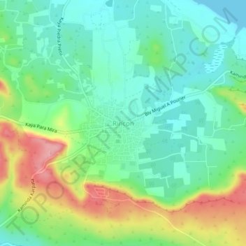
Name: Rincon topographic map, elevation, terrain.
Location: Rincon, Bonaire, Netherlands (12.21867 -68.34982 12.25867 -68.30982)
Average elevation: 40 m
Minimum elevation: 0 m
Maximum elevation: 119 m
Make a donation
Gear up for your next adventure:
As an Amazon Associate, this site earns from qualifying purchases at no extra cost to you.
Other topographic maps
Click on a map to view its topography, its elevation and its terrain.
Sint Eustatius
Sint Eustatius is 6 miles (10 km) long and up to 3 miles (5 km) wide. Topographically, the island is saddle-shaped, with the 602-meter-high dormant volcano Quill (Mount Mazinga), (from Dutch kuil, meaning 'pit'—originally referring to its crater) to the southeast and the smaller summits of Signal Hill/Little…
Average elevation: 12 m
Make a donation
Gear up for your next adventure:
As an Amazon Associate, this site earns from qualifying purchases at no extra cost to you.
Rozendaal
Netherlands > Gelderland > Rozendaal
Dutch topographic map of the municipality of Rozendaal, June 2015
Average elevation: 66 m
Make a donation
Gear up for your next adventure:
As an Amazon Associate, this site earns from qualifying purchases at no extra cost to you.
Den Helder
Dutch Topographic map of Den Helder (town), March 2014.
Average elevation: 0 m
Breda
Topographic map image of the city of Breda, March 2014. Click to enlarge.
Average elevation: 7 m
Make a donation
Gear up for your next adventure:
As an Amazon Associate, this site earns from qualifying purchases at no extra cost to you.
Make a donation
Gear up for your next adventure:
As an Amazon Associate, this site earns from qualifying purchases at no extra cost to you.
Make a donation
Gear up for your next adventure:
As an Amazon Associate, this site earns from qualifying purchases at no extra cost to you.
Make a donation
Gear up for your next adventure:
As an Amazon Associate, this site earns from qualifying purchases at no extra cost to you.
Amersfoort
The construction of the tower and the church was started in 1444. The church was destroyed by an explosion in 1787, but the tower survived, and the layout of the church still can be discerned today through the use of different types of stone in the pavement of the open space that was created. It is now the…
Average elevation: 7 m
Saba
There is an 8.6 hectares (21 acres) cloud forest located at and above 825 metres (2,707 ft) on top of the mountain referred to as the "Elfin Forest Reserve" because of its high altitude mist and mossy appearance. The most dominant tree in the cloud forest is the Mountain Mahogany (Freziera undulate), although…
Average elevation: 2 m
Make a donation
Gear up for your next adventure:
As an Amazon Associate, this site earns from qualifying purchases at no extra cost to you.
Make a donation
Gear up for your next adventure:
As an Amazon Associate, this site earns from qualifying purchases at no extra cost to you.
Make a donation
Gear up for your next adventure:
As an Amazon Associate, this site earns from qualifying purchases at no extra cost to you.
Make a donation
Gear up for your next adventure:
As an Amazon Associate, this site earns from qualifying purchases at no extra cost to you.
Echt-Susteren
Dutch Topographic map of the municipality of Echt-Susteren, June 2015
Average elevation: 38 m