
Corral de Almaguer topographic map
Interactive map
Click on the map to display elevation.
About this map
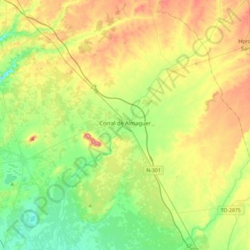
Name: Corral de Almaguer topographic map, elevation, terrain.
Location: Corral de Almaguer, Toledo, Castile-La Mancha, Spain (39.65269 -3.35085 39.86374 -3.01536)
Average elevation: 721 m
Minimum elevation: 657 m
Maximum elevation: 827 m
Other topographic maps
Click on a map to view its topography, its elevation and its terrain.
Quintanar del Rey
Spain > Castile-La Mancha > Quintanar del Rey
Quintanar del Rey, Cuenca, Castile-La Mancha, Spain
Average elevation: 748 m
Tagus
Tagus, Toledo, Castile-La Mancha, 28300, Spain
Average elevation: 622 m