
Tagus topographic map
Interactive map
Click on the map to display elevation.
About this map
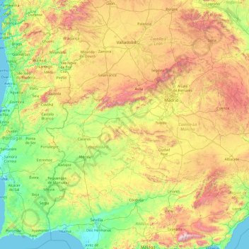
Name: Tagus topographic map, elevation, terrain.
Location: Tagus, Toledo, Castile-La Mancha, 28300, Spain (38.67039 -9.28791 40.80513 -1.69810)
Average elevation: 622 m
Minimum elevation: -1 m
Maximum elevation: 3,380 m
Other topographic maps
Click on a map to view its topography, its elevation and its terrain.
Corral de Almaguer
Corral de Almaguer, Toledo, Castile-La Mancha, Spain
Average elevation: 721 m
Quintanar del Rey
Spain > Castile-La Mancha > Quintanar del Rey
Quintanar del Rey, Cuenca, Castile-La Mancha, Spain
Average elevation: 748 m