
Make a donation
Gear up for your next adventure:
As an Amazon Associate, this site earns from qualifying purchases at no extra cost to you.
Las Vegas topographic map
Click on the map to display elevation.
Make a donation
Gear up for your next adventure:
As an Amazon Associate, this site earns from qualifying purchases at no extra cost to you.
About this map
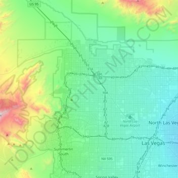
Name: Las Vegas topographic map, elevation, terrain.
Location: Las Vegas, Nevada, United States (36.12955 -115.42397 36.38084 -115.06217)
Average elevation: 924 m
Minimum elevation: 550 m
Maximum elevation: 2,452 m
Make a donation
Gear up for your next adventure:
As an Amazon Associate, this site earns from qualifying purchases at no extra cost to you.
Other topographic maps
Click on a map to view its topography, its elevation and its terrain.
Las Vegas
United States > Nevada > Clark County
The peaks surrounding Las Vegas reach elevations of over 10,000 feet (3,000 m), and act as barriers to the strong flow of moisture from the surrounding area. The elevation is approximately 2,030 ft (620 m) above sea level. According to the United States Census Bureau, the city has a total area of 135.86 sq mi…
Average elevation: 756 m
Las Vegas
United States > Nevada > Clark County
Las Vegas is characterized by its distinctive topography, which features a mix of arid desert landscapes and mountainous terrain. The city itself sits at an elevation of approximately 2,030 feet (620 meters) above sea level, while the surrounding peaks reach heights exceeding 10,000 feet (3,000 meters),…
Average elevation: 767 m
Reno
United States > Nevada > Washoe County
Reno is just east of the Sierra Nevada on the western edge of the Great Basin at an elevation of about 4,400 feet (1,300 m) above sea level. Numerous faults exist throughout the region. Most of these are normal (vertical motion) faults associated with the uplift of the various mountain ranges, including the…
Average elevation: 1,650 m
Reno
United States > Nevada > Washoe County
Reno is characterized by its diverse topography, which is shaped by its elevation and the surrounding mountain ranges. Situated at an average elevation of approximately 4,500 feet (about 1,370 meters), the city is nestled in a high desert region that features a mix of flat valleys and gently rolling hills.…
Average elevation: 1,650 m
Make a donation
Gear up for your next adventure:
As an Amazon Associate, this site earns from qualifying purchases at no extra cost to you.
Pahrump
United States > Nevada > Nye County
Summers in Pahrump are generally very hot and dry, with occasional pushes of monsoonal moisture beginning in early July. Being at a similar elevation to Las Vegas, daytime highs in summer average within a few degrees lower than that of Las Vegas. Record highs are similar between the two cities as well. A…
Average elevation: 1,142 m
Henderson
United States > Nevada > Clark County
Henderson is a city in Clark County, Nevada, United States, about 16 miles (26 km) southeast of downtown Las Vegas. It is the second largest city in Nevada, after Las Vegas, with an estimated population of 320,189 in 2019. The city is part of the Las Vegas Valley. Henderson occupies the southeastern end of the…
Average elevation: 688 m
Carson City
Most of the city proper resides in the Eagle Valley. The Carson River flows from Douglas County through the southwestern edge of both the valley and Carson City. Since the consolidation, the city limits today include several small populated areas outside of this valley. Today the city limits include several…
Average elevation: 1,832 m
Mount Charleston
United States > Nevada > Clark County > Mount Charleston
The town of Mount Charleston is named for nearby Mount Charleston whose Charleston Peak at 11,916 feet (3,632 m) is the highest point in Clark County. The town of Mount Charleston is in a valley of the Spring Mountains to the northwest of Las Vegas, noted for its hiking trails. It is also known for its Retreat…
Average elevation: 2,560 m
Make a donation
Gear up for your next adventure:
As an Amazon Associate, this site earns from qualifying purchases at no extra cost to you.
Pershing County
According to the U.S. Census Bureau, the county has a total area of 6,067 square miles (15,710 km2), of which 6,037 square miles (15,640 km2) is land and 31 square miles (80 km2) (0.5%) is water. The tallest and most topographically prominent mountain in Pershing County is Star Peak at 9,840 ft (3,000 m).
Average elevation: 1,449 m
Nye County
According to the U.S. Census Bureau, the county has an area of 18,199 square miles (47,140 km2), of which 18,182 square miles (47,090 km2) is land and 17 square miles (44 km2) (0.09%) is water. The highest and most topographically prominent mountain in the county is Mount Jefferson at 11,949 feet (3,642 m).
Average elevation: 1,620 m
Elko County
According to the U.S. Census Bureau, the county has a total area of 17,203 square miles (44,560 km2), of which 17,170 square miles (44,500 km2) is land and 33 square miles (85 km2) (0.2%) is water. Not counting Alaska's boroughs (four of which are also larger), it is the fourth-largest county in area in the…
Average elevation: 1,838 m
Make a donation
Gear up for your next adventure:
As an Amazon Associate, this site earns from qualifying purchases at no extra cost to you.
Washoe County
According to the U.S. Census Bureau, the county has a total area of 6,542 square miles (16,940 km2), of which 6,302 square miles (16,320 km2) is land and 240 square miles (620 km2) (3.7%) is water. The highest point in Washoe County is Mount Rose at 10,785 ft (3,287 m), while the most topographically prominent…
Average elevation: 1,528 m
Clark County
The Colorado River forms the county's southeastern boundary, with Hoover Dam forming Lake Mead along much of its length. The lowest point in the state of Nevada is on the Colorado River just south of Laughlin in Clark County, where it flows out of Nevada into California and Arizona. Greater Las Vegas is a…
Average elevation: 968 m
Great Basin
United States > Nevada > Eureka County
The Great Basin is the largest area of contiguous endorheic watersheds, those with no outlets, in North America. It spans nearly all of Nevada, much of Utah, and portions of California, Idaho, Oregon, Wyoming, and Baja California. It is noted for both its arid climate and the basin and range topography that…
Average elevation: 1,918 m
Lander County
The 11,477 ft (3,498 m) summit of Bunker Hill, located in the Toiyabe Range near the Nye County border, is the highest point in the county; while the county's most topographically prominent peak is Mount Lewis.
Average elevation: 1,768 m
Make a donation
Gear up for your next adventure:
As an Amazon Associate, this site earns from qualifying purchases at no extra cost to you.
Make a donation
Gear up for your next adventure:
As an Amazon Associate, this site earns from qualifying purchases at no extra cost to you.
Truckee River
Beavers were re-introduced to the Truckee River watershed and Tahoe Basin by the California Department of Fish and Game (CDFG) and the U. S. Forest Service between 1934 and 1949 in order to prevent stream degradation and to promote wetland restoration. That beaver were once native to the area is supported by…
Average elevation: 1,728 m
Douglas County
According to the U.S. Census Bureau, the county has an area of 738 square miles (1,910 km2), of which 710 square miles (1,800 km2) is land and 28 square miles (73 km2) (3.8%) is water. It is the second-smallest county in Nevada by area. The highest point is East Peak at 9,593 ft (2,924 m), while the most…
Average elevation: 1,940 m
Lyon County
According to the U.S. Census Bureau, the county has a total area of 2,024 square miles (5,240 km2), of which 2,001 square miles (5,180 km2) is land and 23 square miles (60 km2) (1.1%) is water. It is the fourth-smallest county in Nevada by area. The highest point is approximately 10,565 feet (3,220 m) on the…
Average elevation: 1,676 m
White Pine County
In the southeastern part of the county within Great Basin National Park lies 13,065 ft (3,982 m) Wheeler Peak, the tallest independent mountain within Nevada and the second-highest point within the state (the highest point being Boundary Peak). It is also the most topographically prominent peak in the county…
Average elevation: 2,049 m
Make a donation
Gear up for your next adventure:
As an Amazon Associate, this site earns from qualifying purchases at no extra cost to you.
Churchill County
The terrain of Churchill County consists of rugged mountainous ridges, dotted with lakes and ponds. The county's east and west sides are higher than the intermediate valley; its highest point around the county periphery is a ridge on the lower east boundary line, at 9,380 ft (2,860 m) ASL. The county has an…
Average elevation: 1,476 m
Lincoln County
According to the U.S. Census Bureau, the county has an area of 10,637 square miles (27,550 km2), of which 10,633 square miles (27,540 km2) is land and 3.8 square miles (9.8 km2) (0.04%) is water. While only the third-largest county by area in the state of Nevada, it is the seventh-largest county in area in the…
Average elevation: 1,639 m
Henderson
United States > Nevada > Clark County
Henderson is a city in Clark County, Nevada, United States, about 16 miles (26 km) southeast of downtown Las Vegas. It is the second largest city in Nevada, after Las Vegas, with an estimated population of 320,189 in 2019. The city is part of the Las Vegas Valley. Henderson occupies the southeastern end of the…
Average elevation: 688 m
Make a donation
Gear up for your next adventure:
As an Amazon Associate, this site earns from qualifying purchases at no extra cost to you.
Las Vegas Valley
United States > Nevada > Clark County
The Las Vegas Valley lies in a relatively high-altitude portion of the Mojave Desert, with a subtropical hot-desert climate. The Valley generally averages less than 5 in (130 mm) of rain annually. Daily daytime summer temperatures in July and August typically range from 100 °F (38 °C) to 110 °F (43 °C),…
Average elevation: 892 m
Make a donation
Gear up for your next adventure:
As an Amazon Associate, this site earns from qualifying purchases at no extra cost to you.
Humboldt County
The Santa Rosa Range runs through eastern Humboldt County. The highest point in the county, 9,731-ft (2966 m) Granite Peak, is in the range. The most topographically prominent mountain in Humboldt County is unofficially known as Dan Dobbins Peak and is in the remote Jackson Mountains.
Average elevation: 1,558 m
Amargosa Valley
United States > Nevada > Nye County
Amargosa Valley is located at 36.58001 North, 116.44487 West at an elevation of 2,640 feet (805 m) above sea level. The landscape is typical of lower to moderate elevations in the Mojave Desert, with flat expanses of sandy soil punctuated by rocky mounds and hills. Predominant indigenous vegetation is White…
Average elevation: 740 m
Fallon
United States > Nevada > Churchill County
Fallon experiences a cold desert climate, with hot summers and cold winters. Due to Fallon's elevation and aridity, the diurnal temperature variation is quite substantial, especially in the summer months. Fallon's climate is quite dry, due to its location in the rain shadow of the Sierra Nevada. Summer days…
Average elevation: 1,210 m
Make a donation
Gear up for your next adventure:
As an Amazon Associate, this site earns from qualifying purchases at no extra cost to you.
North Las Vegas
United States > Nevada > Clark County
On May 13, 1964, First Lieutenant Raynor Lee Hebert, a student pilot from Port Arthur, Texas, took off from Nellis Air Force Base at approximately 2:00 PM on an F-105 fighter jet. He radioed his flight leader saying that he could not retract his nose gear, and thus couldn't gain altitude. He was at an height…
Average elevation: 858 m
Make a donation
Gear up for your next adventure:
As an Amazon Associate, this site earns from qualifying purchases at no extra cost to you.
Searchlight
United States > Nevada > Clark County > Searchlight
Searchlight is an unincorporated town and census-designated place (CDP) in Clark County, Nevada, United States, at the topographic saddle between two mountain ranges. At the 2020 census it had a population of 445.
Average elevation: 1,087 m
Caliente
United States > Nevada > Lincoln County
Caliente /kæliˈɛni/, /kæliˈɛnti/, formerly known as Culverwell and Calientes, is a city in Lincoln County, Nevada, United States. Its elevation is 4,300 feet (1,300 m). The population was 1,130 at the 2010 census, making it the least populated incorporated city in Nevada. The city's name originated from…
Average elevation: 1,439 m
Make a donation
Gear up for your next adventure:
As an Amazon Associate, this site earns from qualifying purchases at no extra cost to you.
Ely
United States > Nevada > White Pine County
Ely experiences a semi-arid climate (Köppen BSk), and extreme day-night temperature differences year-round. Ely's nighttime temperatures account for it being listed as one of the coldest places in the contiguous United States, with an average of 214.9 nights per year with a minimum temperature of 32 °F (0…
Average elevation: 2,045 m
Tonopah
United States > Nevada > Nye County
Tonopah has an arid, cold desert climate with cool winters and hot summers. Due to Tonopah’s aridity and high altitude, daily temperature ranges are quite large and lows in winter are similar to many continental climates. Nights are cool, even in summer.
Average elevation: 1,842 m
Make a donation
Gear up for your next adventure:
As an Amazon Associate, this site earns from qualifying purchases at no extra cost to you.
Blue Diamond
United States > Nevada > Clark County > Blue Diamond
Blue Diamond is the site of Cottonwood Spring (formerly known as Ojo de Cayetana, or Pearl Spring), a watering place and camp site on the Old Spanish Trail and the later Mormon Road between Mountain Springs and Las Vegas Springs. The springs are located on a mountainside south of the town at 36°02′44″N…
Average elevation: 1,102 m
Make a donation
Gear up for your next adventure:
As an Amazon Associate, this site earns from qualifying purchases at no extra cost to you.
Make a donation
Gear up for your next adventure:
As an Amazon Associate, this site earns from qualifying purchases at no extra cost to you.
Boundary Peak
United States > Nevada > Esmeralda County
Boundary Peak is a mountain in Esmeralda County, Nevada, United States. With a peak elevation of 13,147 feet (4,007 m), it is the highest natural point in the state of Nevada.
Average elevation: 3,515 m
Highland Range Crucial Bighorn Habitat Area
United States > Nevada > Clark County
Average elevation: 917 m
Make a donation
Gear up for your next adventure:
As an Amazon Associate, this site earns from qualifying purchases at no extra cost to you.
Snake Range
United States > Nevada > White Pine County
The Snake Range is a mountain range in White Pine County, Nevada, United States. The south-central portion of the range is included within Great Basin National Park, with most of the remainder included within the Humboldt-Toiyabe National Forest. The range reaches a maximum elevation of 13,065 feet (3,982 m)…
Average elevation: 1,996 m
Make a donation
Gear up for your next adventure:
As an Amazon Associate, this site earns from qualifying purchases at no extra cost to you.
Battle Mountain
United States > Nevada > Lander County > Battle Mountain
Battle Mountain's climate is cool semi-arid (Köppen climate classification BSk), receiving just enough precipitation to avoid arid classification. Due to aridity and high elevation, the area commonly experiences large diurnal temperature variation, particularly in summer, when it averages almost 45 °F or 25…
Average elevation: 1,378 m
Make a donation
Gear up for your next adventure:
As an Amazon Associate, this site earns from qualifying purchases at no extra cost to you.
Gerlach
United States > Nevada > Washoe County
According to the United States Census Bureau, the Gerlach CDP has a total area of 3.1 square miles (8.0 km2), all land. Its elevation is 3,944 ft (1,202 m). Gerlach is approximately 100 miles (160 km) north of Reno, Nevada.
Average elevation: 1,208 m
Make a donation
Gear up for your next adventure:
As an Amazon Associate, this site earns from qualifying purchases at no extra cost to you.
Great Basin National Park
United States > Nevada > White Pine County
The park derives its name from the Great Basin, the dry and mountainous region between the Sierra Nevada and the Wasatch Mountains. Topographically, this area is known as the Basin and Range Province. The park is located about 290 miles (470 km) north of Las Vegas and protects 77,180 acres (31,230 ha).
Average elevation: 2,352 m
Make a donation
Gear up for your next adventure:
As an Amazon Associate, this site earns from qualifying purchases at no extra cost to you.
Incline Village-Crystal Bay
United States > Nevada > Washoe County > Incline Village-Crystal Bay
Average elevation: 2,173 m
Make a donation
Gear up for your next adventure:
As an Amazon Associate, this site earns from qualifying purchases at no extra cost to you.
Make a donation
Gear up for your next adventure:
As an Amazon Associate, this site earns from qualifying purchases at no extra cost to you.
Wells
United States > Nevada > Elko County
According to the United States Census Bureau, the city has a total area of 6.9 square miles (18 km2), all land, at an elevation of 5,630 feet (1,720 m).
Average elevation: 1,744 m
Make a donation
Gear up for your next adventure:
As an Amazon Associate, this site earns from qualifying purchases at no extra cost to you.
Jackpot
United States > Nevada > Elko County
In addition to its casino industry, Jackpot has its own schools, golf course, and post office. Its elevation is approximately 5,200 feet (1,580 m) above sea level.
Average elevation: 1,635 m
North Jackson Mountains Wilderness
United States > Nevada > Humboldt County
Average elevation: 1,747 m
Make a donation
Gear up for your next adventure:
As an Amazon Associate, this site earns from qualifying purchases at no extra cost to you.
Mount Charleston
United States > Nevada > Clark County
The town of Mount Charleston is named for nearby Mount Charleston whose Charleston Peak at 11,916 feet (3,632 m) is the highest point in Clark County. The town of Mount Charleston is in a valley of the Spring Mountains to the northwest of Las Vegas, noted for its hiking trails. It is also known for its Retreat…
Average elevation: 2,594 m
Make a donation
Gear up for your next adventure:
As an Amazon Associate, this site earns from qualifying purchases at no extra cost to you.
Indian Springs
United States > Nevada > Clark County > Indian Springs
One year later, Indian Springs was reactivated as Indian Springs Air Force Base by the new United States Air Force, with a new role as a new weapons systems and aircraft research and testing. Among these missions were support for nuclear arms testing at the Nevada Proving Grounds, high-altitude balloon search…
Average elevation: 1,078 m
Spooner Lake & Backcountry State Park
United States > Nevada > Washoe County > Incline Village-Crystal Bay
Average elevation: 2,108 m
Make a donation
Gear up for your next adventure:
As an Amazon Associate, this site earns from qualifying purchases at no extra cost to you.