
Reno topographic map
Click on the map to display elevation.
Reno
Reno is just east of the Sierra Nevada, on the western edge of the Great Basin at an elevation of about 4,400 feet (1,300 m) above sea level. Numerous faults exist throughout the region. Most of these are normal (vertical motion) faults associated with the extension of the earth's lithosphere and the uplift of the various mountain ranges, including the Sierra Nevada.
About this map
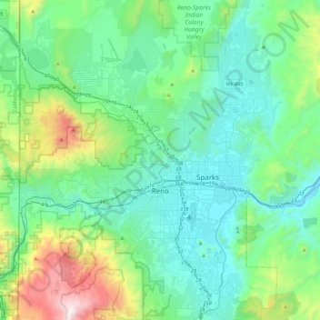
Name: Reno topographic map, elevation, terrain.
Location: Reno, Washoe County, Nevada, United States (39.39243 -120.00232 39.72344 -119.69935)
Average elevation: 1,650 m
Minimum elevation: 1,316 m
Maximum elevation: 3,010 m
Other topographic maps
Click on a map to view its topography, its elevation and its terrain.
Gerlach
United States > Nevada > Washoe County
According to the United States Census Bureau, the Gerlach CDP has a total area of 3.1 square miles (8.0 km2), all land. Its elevation is 3,944 ft (1,202 m). Gerlach is approximately 100 miles (160 km) north of Reno, Nevada.
Average elevation: 1,208 m