
Make a donation
Gear up for your next adventure:
As an Amazon Associate, this site earns from qualifying purchases at no extra cost to you.
Cariboo Regional District topographic map
Click on the map to display elevation.
Make a donation
Gear up for your next adventure:
As an Amazon Associate, this site earns from qualifying purchases at no extra cost to you.
About this map
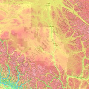
Name: Cariboo Regional District topographic map, elevation, terrain.
Location: Cariboo Regional District, British Columbia, Canada (50.87606 -126.65010 53.54234 -120.13947)
Average elevation: 1,224 m
Minimum elevation: 0 m
Maximum elevation: 3,788 m
Make a donation
Gear up for your next adventure:
As an Amazon Associate, this site earns from qualifying purchases at no extra cost to you.
Other topographic maps
Click on a map to view its topography, its elevation and its terrain.
Shawnigan Lake
Canada > British Columbia > Cowichan Valley Regional District > Area B (Shawnigan Lake)
Average elevation: 128 m
Make a donation
Gear up for your next adventure:
As an Amazon Associate, this site earns from qualifying purchases at no extra cost to you.
Burnaby
Canada > British Columbia > Metro Vancouver Regional District > Burnaby
Burnaby occupies 98.60 square kilometres (38.07 sq mi) and is located at the geographic centre of the Metro Vancouver area and home to the Metro Vancouver regional government in Metrotown. Situated between the city of Vancouver on the west and Port Moody, Coquitlam, and New Westminster on the east, Burnaby is…
Average elevation: 144 m
Annacis Island
Canada > British Columbia > Metro Vancouver Regional District > Delta
Average elevation: 16 m
Make a donation
Gear up for your next adventure:
As an Amazon Associate, this site earns from qualifying purchases at no extra cost to you.
Rock Creek
Canada > British Columbia > Regional District of Kootenay Boundary > Area E (Beaverdell/West Boundary)
Average elevation: 764 m
Thompson River
Canada > British Columbia > Thompson-Nicola Regional District
Average elevation: 1,127 m
Make a donation
Gear up for your next adventure:
As an Amazon Associate, this site earns from qualifying purchases at no extra cost to you.
Kamloops
Canada > British Columbia > Thompson-Nicola Regional District > Kamloops
Average elevation: 875 m
Make a donation
Gear up for your next adventure:
As an Amazon Associate, this site earns from qualifying purchases at no extra cost to you.
Make a donation
Gear up for your next adventure:
As an Amazon Associate, this site earns from qualifying purchases at no extra cost to you.
Make a donation
Gear up for your next adventure:
As an Amazon Associate, this site earns from qualifying purchases at no extra cost to you.
Stanley Park
Canada > British Columbia > Metro Vancouver Regional District > Vancouver
Average elevation: 14 m
Pavilion
The early anglicized version of the village name was Skwailuk, meaning hoar-frost, perhaps indicating the shaded ground remaining frozen during the long winters at this elevation. The Ts'kw'aylaxw First Nation (a.k.a. the Tsk'waylacw First Nation or Tsk'weylecw First Nation), residing on the Pavilion 1 Indian…
Average elevation: 855 m
Make a donation
Gear up for your next adventure:
As an Amazon Associate, this site earns from qualifying purchases at no extra cost to you.
Make a donation
Gear up for your next adventure:
As an Amazon Associate, this site earns from qualifying purchases at no extra cost to you.
Cawston
Canada > British Columbia > Regional District of Okanagan-Similkameen > Area B (Cawston/Lower Similkameen)
Average elevation: 410 m
Make a donation
Gear up for your next adventure:
As an Amazon Associate, this site earns from qualifying purchases at no extra cost to you.
Make a donation
Gear up for your next adventure:
As an Amazon Associate, this site earns from qualifying purchases at no extra cost to you.
Bankeir
Canada > British Columbia > Regional District of Okanagan-Similkameen > Area H (Manning Park/Tulameen/Siwash)
Average elevation: 1,226 m
Garnet Valley Dam
Canada > British Columbia > Regional District of Okanagan-Similkameen > Summerland
Average elevation: 799 m
Whistler
Canada > British Columbia > Squamish-Lillooet Regional District > Whistler Resort Municipality > Whistler
Average elevation: 996 m
Grouse Mountain
Canada > British Columbia > Metro Vancouver Regional District
Grouse Mountain is one of the North Shore Mountains of the Pacific Ranges in the District Municipality of North Vancouver, British Columbia, Canada. With a maximum elevation of over 1,200 m (4,100 feet) at its peak, the mountain is the site of an alpine ski area, Grouse Mountain Resort, which overlooks Greater…
Average elevation: 968 m
Make a donation
Gear up for your next adventure:
As an Amazon Associate, this site earns from qualifying purchases at no extra cost to you.
Dease Lake
Canada > British Columbia > Regional District of Kitimat-Stikine > Area F (Dease Lake)
Dease Lake has a subarctic climate (Köppen Dfc), typical of northern British Columbia. Summers are mild, coupled with chilly nights while winters are severely cold and snowy, with annual snowfall averaging 212.8 cm (83.78 in). Autumn typically begins by early September and lasts into October when winter…
Average elevation: 898 m
Silver Star Mountain Resort
Canada > British Columbia > Regional District of North Okanagan > Area C (Silver Star)
Average elevation: 1,584 m
Langley Township
Canada > British Columbia > Metro Vancouver Regional District > Township of Langley > Langley Township
Average elevation: 37 m
Make a donation
Gear up for your next adventure:
As an Amazon Associate, this site earns from qualifying purchases at no extra cost to you.
Earls Cove
Canada > British Columbia > Sunshine Coast Regional District > Area A (Egmont/Pender Harbour)
Average elevation: 84 m
Edith Lake
Canada > British Columbia > Squamish-Lillooet Regional District > Squamish
Average elevation: 309 m
Crawford Bay
Canada > British Columbia > Regional District of Central Kootenay > Area A (Wynndel/Crawford Bay/Riondel)
Average elevation: 667 m
Make a donation
Gear up for your next adventure:
As an Amazon Associate, this site earns from qualifying purchases at no extra cost to you.
Pogo Mountain
Canada > British Columbia > Alberni-Clayoquot Regional District > Area C (Long Beach)
Average elevation: 818 m
Sunshine Valley
Canada > British Columbia > Fraser Valley Regional District > Area B (South Fraser Canyon/Sunshine Valley)
Average elevation: 1,030 m
Make a donation
Gear up for your next adventure:
As an Amazon Associate, this site earns from qualifying purchases at no extra cost to you.
Panorama Mountain
Canada > British Columbia > Regional District of Kitimat-Stikine > Area A (Nass Valley/Bell Irving)
Average elevation: 1,609 m
Coquitlam
Canada > British Columbia > Metro Vancouver Regional District > Coquitlam
Southwest Coquitlam comprises the original core of the city, with Maillardville and Fraser River industrial sector giving way to the large residential areas of Austin Heights, colloquially referred to as "The Bump" due to its high and flat plateau topography. These older residences, with larger property…
Average elevation: 230 m
Abbotsford
Canada > British Columbia > Fraser Valley Regional District > Abbotsford
Average elevation: 115 m
Hope
Canada > British Columbia > Fraser Valley Regional District > Hope > Hope
Average elevation: 435 m
Make a donation
Gear up for your next adventure:
As an Amazon Associate, this site earns from qualifying purchases at no extra cost to you.
Grizzly Peak
Canada > British Columbia > Regional District of East Kootenay > Area A (Upper Flathead/Elk Valley)
Average elevation: 1,962 m
Morrissey Provincial Park
Canada > British Columbia > Regional District of East Kootenay > Area A (Upper Flathead/Elk Valley)
Average elevation: 1,040 m
Edna Lake
Canada > British Columbia > Thompson-Nicola Regional District > Area N (Beautiful Nicola Valley - South)
Average elevation: 1,304 m
5040 Peak
Canada > British Columbia > Alberni-Clayoquot Regional District > Area D (Sproat Lake)
Average elevation: 1,092 m
Make a donation
Gear up for your next adventure:
As an Amazon Associate, this site earns from qualifying purchases at no extra cost to you.
Deka Lake
Canada > British Columbia > Cariboo Regional District > Area L (Lone Butte/Interlakes)
Average elevation: 1,141 m
Alleyne Lake
Canada > British Columbia > Thompson-Nicola Regional District > Area N (Beautiful Nicola Valley - South)
Average elevation: 1,089 m
Quartz Creek
Canada > British Columbia > Columbia-Shuswap Regional District > Area A (Kicking Horse/Kinbasket Lake)
Average elevation: 1,352 m
Rocky Mountains
Canada > British Columbia > Northern Rockies Regional Municipality
Average elevation: 1,329 m
Make a donation
Gear up for your next adventure:
As an Amazon Associate, this site earns from qualifying purchases at no extra cost to you.
Loon Lake
Canada > British Columbia > Regional District of North Okanagan > Area D (Trinity/West Creighton)
Average elevation: 1,360 m
William Lake
Canada > British Columbia > Regional District of Mount Waddington > Area B (Quatsino Sound/Cape Scott)
Average elevation: 158 m
Pender Hill
Canada > British Columbia > Sunshine Coast Regional District > Area A (Egmont/Pender Harbour)
Average elevation: 48 m
Make a donation
Gear up for your next adventure:
As an Amazon Associate, this site earns from qualifying purchases at no extra cost to you.
South Slocan
Canada > British Columbia > Regional District of Central Kootenay > Area H (The Slocan Valley)
Average elevation: 578 m
Rocky Mountains
Canada > British Columbia > Regional District of Fraser-Fort George > Area F (Willow River/Upper Fraser)
Average elevation: 1,252 m
Thompson Glacier
Canada > British Columbia > Thompson-Nicola Regional District > Area B (Thompson Headwaters)
Average elevation: 2,313 m
Riondel
Canada > British Columbia > Regional District of Central Kootenay > Area A (Wynndel/Crawford Bay/Riondel)
Average elevation: 675 m
Make a donation
Gear up for your next adventure:
As an Amazon Associate, this site earns from qualifying purchases at no extra cost to you.
Shearwater
Canada > British Columbia > Central Coast Regional District > Area A (Ocean Falls/Outer Coast)
Average elevation: 45 m
Tent Mountain
Canada > British Columbia > Regional District of East Kootenay > Area A (Upper Flathead/Elk Valley)
Average elevation: 1,873 m
Carmi
Canada > British Columbia > Regional District of Kootenay Boundary > Area E (Beaverdell/West Boundary)
Average elevation: 988 m
Mazinaw Mountain
Canada > British Columbia > Regional District of Central Kootenay > Area D (Lardeau Valley/Duncan Lake)
Average elevation: 2,578 m
Make a donation
Gear up for your next adventure:
As an Amazon Associate, this site earns from qualifying purchases at no extra cost to you.
Silver Star Mountain
Canada > British Columbia > Regional District of North Okanagan > Area C (Silver Star)
Average elevation: 1,706 m
Rocky Mountains
Canada > British Columbia > Peace River Regional District > Area B (Finlay Valley/Beatton Valley)
Average elevation: 1,019 m
Bouchie Lake
Canada > British Columbia > Cariboo Regional District > Area B (Quesnel West/Bouchie Lake)
Average elevation: 699 m
Make a donation
Gear up for your next adventure:
As an Amazon Associate, this site earns from qualifying purchases at no extra cost to you.
Mill Bay
Canada > British Columbia > Cowichan Valley Regional District > Area A (Mill Bay / Malahat)
Average elevation: 61 m
Woss
Canada > British Columbia > Regional District of Mount Waddington > Area D (Nimpkish Valley/Cormorant Island)
Average elevation: 200 m
Oyster River
Canada > British Columbia > Strathcona Regional District > Area D (Oyster Bay/Buttle Lake) > Oyster River
Average elevation: 24 m
Shuswap
Canada > British Columbia > Regional District of East Kootenay > Area F (Columbia Lake/Windermere Lake)
Average elevation: 926 m
Make a donation
Gear up for your next adventure:
As an Amazon Associate, this site earns from qualifying purchases at no extra cost to you.
Gabriola
Canada > British Columbia > Regional District of Nanaimo > Area B (DeCourcy/Gabriola/Mudge)
Gabriola is about 14 kilometres (9 mi) long by 4.2 kilometres (2.6 mi) wide on average with a land area of 57.6 square kilometres (22.2 sq mi). The topography varies from flat sandy beaches at sea level to forested hills rising to 160 metres (525 ft) on Stoney Ridge in the centre of the island.
Average elevation: 31 m
Errington
Canada > British Columbia > Regional District of Nanaimo > Area F (Alberni Highway)
Average elevation: 120 m
The Commons Field
Canada > British Columbia > Regional District of Central Okanagan > Kelowna
Average elevation: 442 m
Woodlot 0007
Canada > British Columbia > Metro Vancouver Regional District > Maple Ridge
Average elevation: 322 m
Make a donation
Gear up for your next adventure:
As an Amazon Associate, this site earns from qualifying purchases at no extra cost to you.
Agur Lake
Canada > British Columbia > Regional District of Okanagan-Similkameen > Area F (Trout Creek Valley)
Average elevation: 1,178 m
Faulder
Canada > British Columbia > Regional District of Okanagan-Similkameen > Area F (Trout Creek Valley)
Average elevation: 850 m
Crooked River
Canada > British Columbia > Regional District of Fraser-Fort George > Area G (Crooked River/Parsnip)
Average elevation: 749 m
Carp Lake
Canada > British Columbia > Regional District of Fraser-Fort George > Area G (Crooked River/Parsnip)
Average elevation: 865 m
Make a donation
Gear up for your next adventure:
As an Amazon Associate, this site earns from qualifying purchases at no extra cost to you.
Pine River
Canada > British Columbia > Peace River Regional District > Area E (Moberly Lake/Sukunka Valley)
Average elevation: 973 m
Parkland
Canada > British Columbia > Peace River Regional District > Area D (Kiskatinaw Valley)
Average elevation: 726 m
Walnut Park
Canada > British Columbia > Metro Vancouver Regional District > Surrey
Average elevation: 49 m
Make a donation
Gear up for your next adventure:
As an Amazon Associate, this site earns from qualifying purchases at no extra cost to you.