
Make a donation
Gear up for your next adventure:
As an Amazon Associate, this site earns from qualifying purchases at no extra cost to you.
Burnaby topographic map
Click on the map to display elevation.
Make a donation
Gear up for your next adventure:
As an Amazon Associate, this site earns from qualifying purchases at no extra cost to you.
Burnaby
Burnaby occupies 98.60 square kilometres (38.07 sq mi) and is located at the geographic centre of the Metro Vancouver area and home to the Metro Vancouver regional government in Metrotown. Situated between the city of Vancouver on the west and Port Moody, Coquitlam, and New Westminster on the east, Burnaby is bounded by Burrard Inlet and the Fraser River on the north and south, respectively. Burnaby, Vancouver and New Westminster collectively occupy the major portion of the Burrard Peninsula. The elevation of Burnaby ranges from sea level to a maximum of 370 metres (1,210 ft) atop Burnaby Mountain. Due to its elevation, the city of Burnaby typically has quite a bit more snowfall during the winter months than nearby Vancouver or Richmond. Overall, the physical landscape of Burnaby is one of hills, ridges, valleys and an alluvial plain. The land features and their relative locations have had an influence on the location, type and form of development in the city.
Make a donation
Gear up for your next adventure:
As an Amazon Associate, this site earns from qualifying purchases at no extra cost to you.
About this map
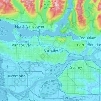
Name: Burnaby topographic map, elevation, terrain.
Average elevation: 144 m
Minimum elevation: -4 m
Maximum elevation: 1,429 m
Make a donation
Gear up for your next adventure:
As an Amazon Associate, this site earns from qualifying purchases at no extra cost to you.
Other topographic maps
Click on a map to view its topography, its elevation and its terrain.
Deer Lake Park
Canada > British Columbia > Metro Vancouver Regional District > Burnaby
Average elevation: 64 m
Burnaby Lake
Canada > British Columbia > Metro Vancouver Regional District > Burnaby
Average elevation: 32 m
Central Park
Canada > British Columbia > Metro Vancouver Regional District > Burnaby
Average elevation: 113 m
Brentwood
Canada > British Columbia > Metro Vancouver Regional District > Burnaby
Average elevation: 69 m
Make a donation
Gear up for your next adventure:
As an Amazon Associate, this site earns from qualifying purchases at no extra cost to you.
Barnet Marine Park
Canada > British Columbia > Metro Vancouver Regional District > Burnaby
Average elevation: 95 m
Stride Hill
Canada > British Columbia > Metro Vancouver Regional District > Burnaby
Average elevation: 68 m
Riverway Sports Complex
Canada > British Columbia > Metro Vancouver Regional District > Burnaby
Average elevation: 42 m
Maywood
Canada > British Columbia > Metro Vancouver Regional District > Burnaby
Average elevation: 113 m
Make a donation
Gear up for your next adventure:
As an Amazon Associate, this site earns from qualifying purchases at no extra cost to you.
Deer Lake
Canada > British Columbia > Metro Vancouver Regional District > Burnaby
Average elevation: 60 m
Burnaby Lake Regional Park
Canada > British Columbia > Metro Vancouver Regional District > Burnaby
Average elevation: 51 m
Government Road
Canada > British Columbia > Metro Vancouver Regional District > Burnaby
Average elevation: 45 m
Stoney Creek Park
Canada > British Columbia > Metro Vancouver Regional District > Burnaby
Average elevation: 85 m
Make a donation
Gear up for your next adventure:
As an Amazon Associate, this site earns from qualifying purchases at no extra cost to you.