
Make a donation
Gear up for your next adventure:
As an Amazon Associate, this site earns from qualifying purchases at no extra cost to you.
Spallumcheen topographic map
Click on the map to display elevation.
Make a donation
Gear up for your next adventure:
As an Amazon Associate, this site earns from qualifying purchases at no extra cost to you.
About this map
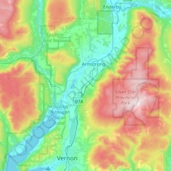
Name: Spallumcheen topographic map, elevation, terrain.
Average elevation: 837 m
Minimum elevation: 339 m
Maximum elevation: 1,885 m
Make a donation
Gear up for your next adventure:
As an Amazon Associate, this site earns from qualifying purchases at no extra cost to you.
Other topographic maps
Click on a map to view its topography, its elevation and its terrain.
Mabel Lake
Canada > British Columbia > Regional District of North Okanagan > Area F (Grindrod/Ashton Creek/Mabel Lake)
Average elevation: 1,164 m
Echo Lake Provincial Park
Canada > British Columbia > Regional District of North Okanagan > Area D (Trinity/West Creighton)
Average elevation: 1,119 m
Make a donation
Gear up for your next adventure:
As an Amazon Associate, this site earns from qualifying purchases at no extra cost to you.
Enderby
Canada > British Columbia > Regional District of North Okanagan
Latitude-Longitude: 50°33′03.0″N 119°08′22.7″W / 50.550833°N 119.139639°W / 50.550833; -119.139639 elevation: 360 metres
Average elevation: 382 m
Enderby Cliffs
Canada > British Columbia > Regional District of North Okanagan > Area F (Grindrod/Ashton Creek/Mabel Lake)
Average elevation: 911 m
Curtis Lake
Canada > British Columbia > Regional District of North Okanagan > Area D (Trinity/West Creighton)
Average elevation: 1,328 m
Monashee Provincial Park
Canada > British Columbia > Regional District of North Okanagan > Area E (Cherryville/East Creighton)
Average elevation: 1,677 m
Make a donation
Gear up for your next adventure:
As an Amazon Associate, this site earns from qualifying purchases at no extra cost to you.
Silver Star Provincial Park
Canada > British Columbia > Regional District of North Okanagan > Area C (Silver Star)
Average elevation: 1,483 m
Loon Lake
Canada > British Columbia > Regional District of North Okanagan > Area D (Trinity/West Creighton)
Average elevation: 1,360 m
Spectrum Lake
Canada > British Columbia > Regional District of North Okanagan > Area E (Cherryville/East Creighton)
Average elevation: 1,240 m
Make a donation
Gear up for your next adventure:
As an Amazon Associate, this site earns from qualifying purchases at no extra cost to you.
Area B (Westside/Swan Lake/Kalamalka Lake)
Canada > British Columbia > Regional District of North Okanagan
Average elevation: 1,012 m
Big Peters Lake
Canada > British Columbia > Regional District of North Okanagan > Area E (Cherryville/East Creighton)
Average elevation: 1,850 m
Cooke Creek
Canada > British Columbia > Regional District of North Okanagan > Area F (Grindrod/Ashton Creek/Mabel Lake)
Average elevation: 838 m
Make a donation
Gear up for your next adventure:
As an Amazon Associate, this site earns from qualifying purchases at no extra cost to you.
Enderby
Canada > British Columbia > Regional District of North Okanagan
Latitude-Longitude: 50°33′03.0″N 119°08′22.7″W / 50.550833°N 119.139639°W / 50.550833; -119.139639 elevation: 360 metres
Average elevation: 382 m
Area F (Grindrod/Ashton Creek/Mabel Lake)
Canada > British Columbia > Regional District of North Okanagan
Average elevation: 1,081 m
Make a donation
Gear up for your next adventure:
As an Amazon Associate, this site earns from qualifying purchases at no extra cost to you.
Area F (Grindrod/Ashton Creek/Mabel Lake)
Canada > British Columbia > Regional District of North Okanagan
Average elevation: 1,081 m
Area D (Trinity/West Creighton)
Canada > British Columbia > Regional District of North Okanagan
Average elevation: 1,181 m
Area C (Silver Star)
Canada > British Columbia > Regional District of North Okanagan
Average elevation: 956 m
Area E (Cherryville/East Creighton)
Canada > British Columbia > Regional District of North Okanagan
Average elevation: 1,257 m
Make a donation
Gear up for your next adventure:
As an Amazon Associate, this site earns from qualifying purchases at no extra cost to you.
Ellison Elemtary Park
Canada > British Columbia > Regional District of North Okanagan > Vernon
Average elevation: 399 m