
東扇島 (Insel) topographic map
Interactive map
Click on the map to display elevation.
About this map
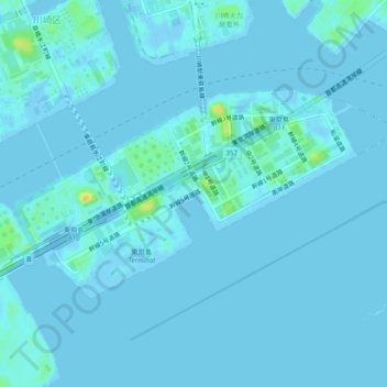
Name: 東扇島 (Insel) topographic map, elevation, terrain.
Location: 東扇島 (Insel), 川崎市, 神奈川縣, 210-0869, 日本 (35.48500 139.73629 35.50622 139.78443)
Average elevation: 2 m
Minimum elevation: -8 m
Maximum elevation: 25 m
Other topographic maps
Click on a map to view its topography, its elevation and its terrain.