
Make a donation
Gear up for your next adventure:
As an Amazon Associate, this site earns from qualifying purchases at no extra cost to you.
Roßla topographic map
Click on the map to display elevation.
Make a donation
Gear up for your next adventure:
As an Amazon Associate, this site earns from qualifying purchases at no extra cost to you.
Roßla
Roßla verfügt über einen Bahnhof an der Bahnstrecke Halle–Hann. Münden und wird stündlich vom Regional-Express der Relation Halle (Saale) ↔ Leinefelde / Kassel-Wilhelmshöhe bedient.
Make a donation
Gear up for your next adventure:
As an Amazon Associate, this site earns from qualifying purchases at no extra cost to you.
About this map
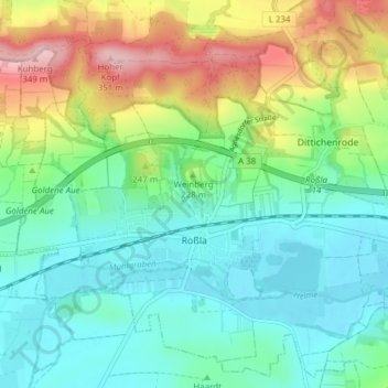
Name: Roßla topographic map, elevation, terrain.
Location: Roßla, Südharz, Mansfeld-Südharz, Sachsen-Anhalt, Deutschland (51.44606 11.03945 51.49082 11.11598)
Average elevation: 206 m
Minimum elevation: 142 m
Maximum elevation: 352 m
Make a donation
Gear up for your next adventure:
As an Amazon Associate, this site earns from qualifying purchases at no extra cost to you.
Other topographic maps
Click on a map to view its topography, its elevation and its terrain.
Make a donation
Gear up for your next adventure:
As an Amazon Associate, this site earns from qualifying purchases at no extra cost to you.
Make a donation
Gear up for your next adventure:
As an Amazon Associate, this site earns from qualifying purchases at no extra cost to you.
Rohnetal
Deutschland > Sachsen-Anhalt > Mansfeld-Südharz > Allstedt > Wolferstedt
Average elevation: 172 m
Make a donation
Gear up for your next adventure:
As an Amazon Associate, this site earns from qualifying purchases at no extra cost to you.
Großer Auerberg
Deutschland > Sachsen-Anhalt > Mansfeld-Südharz
Der Große Auerberg im Harz ist ein 580,4 m ü. NHN hoher Berg bei Stolberg im Gemeindegebiet von Südharz im Landkreis Mansfeld-Südharz in Sachsen-Anhalt. Es handelt sich um einen Doppelgipfel von 580,4 m (Großer Auerberg) und 580,3 m (Josephshöhe) Höhe, die etwa 470 m auseinander liegen.
Average elevation: 479 m
Popperode
Deutschland > Sachsen-Anhalt > Mansfeld-Südharz > Sangerhausen > Popperode
Average elevation: 328 m
Make a donation
Gear up for your next adventure:
As an Amazon Associate, this site earns from qualifying purchases at no extra cost to you.
Hedersleben (b. Eisleben)
Deutschland > Sachsen-Anhalt > Mansfeld-Südharz > Lutherstadt Eisleben > Hedersleben (b. Eisleben)
Average elevation: 201 m
Wolferode
Deutschland > Sachsen-Anhalt > Mansfeld-Südharz > Lutherstadt Eisleben > Wolferode
Average elevation: 230 m
Sittendorf
Deutschland > Sachsen-Anhalt > Mansfeld-Südharz > Kelbra (Kyffhäuser)
Average elevation: 203 m