
Camber topographic map
Interactive map
Click on the map to display elevation.
About this map
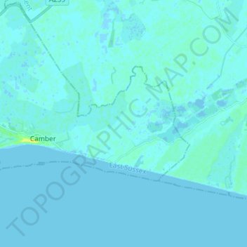
Name: Camber topographic map, elevation, terrain.
Location: Camber, Rother, East Sussex, England, United Kingdom (50.92203 0.74663 50.95762 0.86786)
Average elevation: 1 m
Minimum elevation: -3 m
Maximum elevation: 18 m
Other topographic maps
Click on a map to view its topography, its elevation and its terrain.
Bexhill-on-Sea
United Kingdom > England > East Sussex > Rother
Bexhill-on-Sea, Rother, East Sussex, England, TN39 3JX, United Kingdom
Average elevation: 13 m
Playden
United Kingdom > England > East Sussex > Rother
Playden, Rother, East Sussex, England, United Kingdom
Average elevation: 17 m
Northbridge Street
United Kingdom > England > East Sussex > Rother > Robertsbridge
Northbridge Street, Salehurst and Robertsbridge, Robertsbridge, Rother, East Sussex, England, TN32 5NT, United Kingdom
Average elevation: 40 m
Burwash Weald
United Kingdom > England > East Sussex > Rother
Burwash Weald, Rother, East Sussex, England, TN19 7LB, United Kingdom
Average elevation: 97 m
Ring Wood
United Kingdom > England > East Sussex > Rother > Crowhurst
Ring Wood, Bexhill-on-Sea, Crowhurst, Rother, East Sussex, England, United Kingdom
Average elevation: 24 m
Icklesham
United Kingdom > England > East Sussex > Rother
Icklesham, Rother, East Sussex, England, United Kingdom
Average elevation: 26 m
Bodiam
United Kingdom > England > East Sussex > Rother
Bodiam, Rother, East Sussex, England, United Kingdom
Average elevation: 27 m
Robertsbridge
United Kingdom > England > East Sussex > Rother
Robertsbridge, Rother, East Sussex, England, TN32 5AL, United Kingdom
Average elevation: 38 m
Brede
United Kingdom > England > East Sussex > Rother
Brede, Rother, East Sussex, England, United Kingdom
Average elevation: 40 m
Witherenden Hill
United Kingdom > England > East Sussex > Rother
Witherenden Hill, Burwash, Rother, East Sussex, England, TN19 7JJ, United Kingdom
Average elevation: 61 m
Quickbourne
United Kingdom > England > East Sussex > Rother > Northiam
Quickbourne, Northiam, Rother, East Sussex, England, TN31 6QX, United Kingdom
Average elevation: 23 m
Netherfield
United Kingdom > England > East Sussex > Rother
Netherfield, Rother, East Sussex, England, TN33 9QE, United Kingdom
Average elevation: 90 m
Rye Harbour
United Kingdom > England > East Sussex > Rother
Rye Harbour, Rother, East Sussex, England, TN31 7HX, United Kingdom
Average elevation: 2 m
Hurst Green
United Kingdom > England > East Sussex > Rother > Hurst Green
Hurst Green, Rother, East Sussex, England, United Kingdom
Average elevation: 54 m
Pett
United Kingdom > England > East Sussex > Rother
Pett, Rother, East Sussex, England, United Kingdom
Average elevation: 21 m
Catsfield
United Kingdom > England > East Sussex > Rother > Catsfield
Catsfield, Rother, East Sussex, England, United Kingdom
Average elevation: 53 m
Ashburnham
United Kingdom > England > East Sussex > Rother
Ashburnham, Rother, East Sussex, England, TN33 9NU, United Kingdom
Average elevation: 42 m
Ticehurst
United Kingdom > England > East Sussex > Rother
Ticehurst, Rother, East Sussex, England, United Kingdom
Average elevation: 81 m
Bewl Water
United Kingdom > England > East Sussex > Rother > Ticehurst
Bewl Water, Ticehurst, Rother, East Sussex, England, United Kingdom
Average elevation: 92 m
Sedlescombe
United Kingdom > England > East Sussex > Rother
Sedlescombe, Rother, East Sussex, England, United Kingdom
Average elevation: 47 m
Winchelsea
United Kingdom > England > East Sussex > Rother
Winchelsea, Rother, East Sussex, England, TN36 4EN, United Kingdom
Average elevation: 12 m
Camber Sands
United Kingdom > England > East Sussex > Rother > Camber
Camber Sands, Camber, Rother, East Sussex, England, United Kingdom
Average elevation: 2 m
Peasmarsh
United Kingdom > England > East Sussex > Rother
Peasmarsh, Rother, East Sussex, England, United Kingdom
Average elevation: 24 m
Battle
United Kingdom > England > East Sussex > Rother > Battle
Battle, Rother, East Sussex, England, United Kingdom
Average elevation: 66 m
Cripps Corner
United Kingdom > England > East Sussex > Rother
Cripps Corner, Rother, East Sussex, England, TN32 5FN, United Kingdom
Average elevation: 63 m
Union Street
United Kingdom > England > East Sussex > Rother > Flimwell > Union Street
Union Street, Ticehurst, Flimwell, Rother, East Sussex, South East England, England, TN5 7NN, United Kingdom
Average elevation: 97 m
Northiam
United Kingdom > England > East Sussex > Rother
Northiam, Rother, East Sussex, England, United Kingdom
Average elevation: 34 m
Whatlington
United Kingdom > England > East Sussex > Rother
Whatlington, Rother, East Sussex, England, United Kingdom
Average elevation: 53 m
Etchingham
United Kingdom > England > East Sussex > Rother
Etchingham, Rother, East Sussex, England, United Kingdom
Average elevation: 46 m
Mountfield
United Kingdom > England > East Sussex > Rother
Mountfield, Rother, East Sussex, South East England, England, United Kingdom
Average elevation: 63 m
Udimore
United Kingdom > England > East Sussex > Rother
Udimore, Rother, East Sussex, England, United Kingdom
Average elevation: 23 m
John's Cross
United Kingdom > England > East Sussex > Rother > Mountfield > John's Cross
John's Cross, Mountfield, Rother, East Sussex, South East England, England, TN32 5JJ, United Kingdom
Average elevation: 53 m
Flimwell
United Kingdom > England > East Sussex > Rother
Flimwell, Rother, East Sussex, England, TN5 7PG, United Kingdom
Average elevation: 96 m
Rye
United Kingdom > England > East Sussex > Rother
Rye, Rother, East Sussex, England, United Kingdom
Average elevation: 7 m
Telham
United Kingdom > England > East Sussex > Rother
Telham, Rother, East Sussex, England, TN33 0FN, United Kingdom
Average elevation: 68 m
Brightling
United Kingdom > England > East Sussex > Rother
Brightling, Rother, East Sussex, England, United Kingdom
Average elevation: 94 m
Beckley
United Kingdom > England > East Sussex > Rother > Beckley
Beckley, Rother, East Sussex, England, United Kingdom
Average elevation: 29 m