
Golestan Province topographic map
Interactive map
Click on the map to display elevation.
About this map
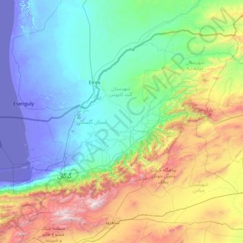
Name: Golestan Province topographic map, elevation, terrain.
Location: Golestan Province, Iran (36.50483 53.66019 38.12528 56.36948)
Average elevation: 659 m
Minimum elevation: -29 m
Maximum elevation: 3,859 m
Other topographic maps
Click on a map to view its topography, its elevation and its terrain.
Mitu
Iran > Kurdistan Province > Saqqez County > دهستان تموغه
Mitu, دهستان تموغه, بخش مرکزی شهرستان سقز, Saqqez County, Kurdistan Province, Iran
Average elevation: 1,684 m
Tehran
Tehran, بخش مرکزی شهرستان تهران, Tehran County, Tehran Province, Iran
Average elevation: 1,539 m
Shahid Razavi
Iran > Razavi Khorasan > Mashhad County > Mashhad
Shahid Razavi, Quarter 1 of District 11, District 11, Mashhad, بخش مرکزی شهرستان مشهد, Mashhad County, Razavi Khorasan, Iran
Average elevation: 1,048 m
Baba Jan, East Azerbaijan
Iran > East Azerbaijan Province > Ahar County > دهستان قشلاق
Baba Jan, East Azerbaijan, دهستان قشلاق, بخش مرکزی, Ahar County, East Azerbaijan Province, Iran
Average elevation: 1,752 m
Qom
Iran > Qom Province > Qom County
Qom, Qom Central District, Qom County, Qom Province, Iran
Average elevation: 943 m
Sanandaj
Iran > Kurdistan Province > Sanandaj County
Sanandaj, بخش مرکزی, Sanandaj County, Kurdistan Province, Iran
Average elevation: 1,608 m
دهستان خاوومیرآباد
Iran > Kurdistan Province > Marivan County
دهستان خاوومیرآباد, بخش خاوومیرآباد, Marivan County, Kurdistan Province, Iran
Average elevation: 1,519 m
Andis
Iran > East Azerbaijan Province > Heris County
Andis, بخش مرکزی, Heris County, East Azerbaijan Province, Iran
Average elevation: 1,938 m
Igdir
Iran > West Azerbaijan Province > Urumia County > دهستان بکشلوچای
Igdir, دهستان بکشلوچای, بخش مرکزی, Urumia County, West Azerbaijan Province, Iran
Average elevation: 1,281 m
Abidar
Abidar, دهستان کلاردشت غربی, Kelardasht County, Mazandaran Province, Iran
Average elevation: 3,765 m
Taleghan County
Taleghan County, Alborz Province, Iran
Average elevation: 2,296 m
Esker
Iran > Kerman Province > Rabor County > Rabor
Esker, Rabor, بخش مرکزی, Rabor County, Kerman Province, Iran
Average elevation: 2,664 m
Mud
Iran > South Khorasan Province > Mud
Mud, مود, بخش مود, Sarbisheh County, South Khorasan Province, Iran
Average elevation: 1,888 m
Zabol
Iran > Sistan and Baluchestan Province > Zabol
Zabol, قائم آباد, بخش مرکزی, زابل, Sistan and Baluchestan Province, 432, Iran
Average elevation: 481 m
رزکان
Iran > Tehran Province > رزکان
رزکان, Shahriar County, Tehran Province, Iran
Average elevation: 1,146 m
East Azerbaijan Province
Iran > East Azerbaijan Province
East Azerbaijan Province, Iran
Average elevation: 1,529 m
Zagros Mountains
Iran > Isfahan Province > پادناوسطی
Zagros Mountains, پادناوسطی, بخش پادنا, Semirom County, Isfahan Province, Iran
Average elevation: 3,846 m
Qeshm Island
Iran > Hormozgan Province > رمکان
Qeshm Island, رمکان, بخش مرکزی شهرستان قشم, Qeshm County, Hormozgan Province, Iran
Average elevation: 29 m
Ahar
Iran > East Azerbaijan Province > Ahar
Ahar, بخش مرکزی, Ahar County, East Azerbaijan Province, Iran
Average elevation: 1,382 m
Bakhtegan Lake
Iran > Fars Province > حناء
Bakhtegan Lake, حناء, آباده طشک, Neyriz County, Fars Province, Iran
Average elevation: 1,812 m
Urmia
Iran > West Azerbaijan Province > Urmia
Urmia, بخش مرکزی, Urumia County, West Azerbaijan Province, Iran
Average elevation: 1,384 m
Arak
Iran > Markazi Province > Arak
Arak, بخش مرکزی, Arak County, Markazi Province, Iran
Average elevation: 1,873 m
Kant
Iran > Sistan and Baluchestan Province > Kant
Kant, بخش هیدوج, Sib and Suran County, Sistan and Baluchestan Province, Iran
Average elevation: 1,234 m
Hamoun Lake
Iran > Sistan and Baluchestan Province > Zehak
Hamoun Lake, Zehak, بخش مرکزی, Zahak County, Sistan and Baluchestan Province, Iran
Average elevation: 491 m