
Make a donation
Gear up for your next adventure:
As an Amazon Associate, this site earns from qualifying purchases at no extra cost to you.
Bushehr Province topographic map
Click on the map to display elevation.
Make a donation
Gear up for your next adventure:
As an Amazon Associate, this site earns from qualifying purchases at no extra cost to you.
About this map
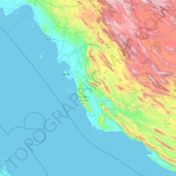
Name: Bushehr Province topographic map, elevation, terrain.
Location: Bushehr Province, Iran (26.98941 49.58014 30.29496 52.91341)
Average elevation: 501 m
Minimum elevation: -3 m
Maximum elevation: 3,149 m
Make a donation
Gear up for your next adventure:
As an Amazon Associate, this site earns from qualifying purchases at no extra cost to you.
Other topographic maps
Click on a map to view its topography, its elevation and its terrain.
Make a donation
Gear up for your next adventure:
As an Amazon Associate, this site earns from qualifying purchases at no extra cost to you.
Baba Jan, East Azerbaijan
Iran > East Azerbaijan Province > Ahar County > دهستان قشلاق
Average elevation: 1,752 m
Make a donation
Gear up for your next adventure:
As an Amazon Associate, this site earns from qualifying purchases at no extra cost to you.