
County Kerry topographic map
Interactive map
Click on the map to display elevation.
County Kerry
Bounded by the Atlantic Ocean, Kerry is Ireland's most westerly county. Its rugged coastline stretches for 886 kilometres (551 miles) and is characterised by bays, sea cliffs, beaches and many small offshore islands, of which the Blaskets and the Skelligs are the most notable. The county's peninsulas have a hilly to mountainous topography, with the MacGillycuddy's Reeks on Iveragh rising to over 1,000 m (3,300 ft). By contrast, its interior regions are mostly flat, interspersed with low mountain ranges such as the Stacks and the Mullaghareirks. The climate of Kerry is dominated by the North Atlantic Current and is usually mild and humid, with abundant precipitation. This allows for the growth of a wide variety of temperate and sub-tropical plants not typically found at such northerly latitudes.
About this map
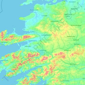
Name: County Kerry topographic map, elevation, terrain.
Location: County Kerry, Munster, Ireland (51.68820 -10.66262 52.60245 -9.11875)
Average elevation: 123 m
Minimum elevation: -2 m
Maximum elevation: 971 m
Ireland trails, hiking, mountain biking, running and outdoor activities
Other topographic maps
Click on a map to view its topography, its elevation and its terrain.
Brandon Hill
Brandon Hill (Irish: Cnoc Bhréanail) is the highest mountain in County Kilkenny, Ireland, with an elevation of 515 m (1,690 ft) and prominence at 448 m (1,470 ft). The South Leinster Way, a long-distance trail, meandering through the Barrow Valley and traverses Brandon Hill. The village of Graiguenamanagh and…
Average elevation: 294 m
Mangerton
Mangerton Mountain's height and topographic prominence, qualifies it to meet the British Isles Marilyn classification, as well as the Arderin, Simm and Hewitt classifications. Mangerton Mountain ranks as the 10th-highest mountain in Ireland on the MountainViews Online Database, 100 Highest Irish Mountains,…
Average elevation: 657 m
Bruff
Ireland > County Limerick > The Municipal District of Cappamore — Kilmallock
Average elevation: 68 m
Lambay Island
Lambay Island is the largest island off the east coast of Ireland. It covers about 2.5 km2 (0.97 sq mi). The highest point – a hill known as Knockbane – rises to 126 m (413 ft). The island's high ground lies to the east and aside from Knockbane includes Heath Hill and Tinian Hill, and in the extreme…
Average elevation: 14 m
Rathdangan
Evidence of habitation is shown by a Bronze Age burial cist, a fort dating from at least the eight-century and a Norman moat at Killamoat. A 1668 survey records 18 houses in the village. Due to its mountainous elevation, in the severe winters of 1947, 1963 and 1982, Rathdangan was isolated for weeks. In 1985…
Average elevation: 228 m