
Griffith Park topographic map
Click on the map to display elevation.
About this map
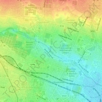
Name: Griffith Park topographic map, elevation, terrain.
Average elevation: 26 m
Minimum elevation: 3 m
Maximum elevation: 52 m
County Dublin trails, hiking, mountain biking, running and outdoor activities
Other topographic maps
Click on a map to view its topography, its elevation and its terrain.
Drimnagh Castle
Ireland > County Dublin > Dublin
By the mid-19th century, the castle was owned by the then Marquess of Lansdowne, with Samuel Lewis's Topographical Dictionary of Ireland (printed 1837) stating that it was an "irregular pile", the "property of the Marquess of Lansdowne [..] occupied by Mr. E. Cavanagh".
Average elevation: 45 m