Geolocate

County Limerick topographic map

Interactive map

Click on the map to display elevation.

About this map

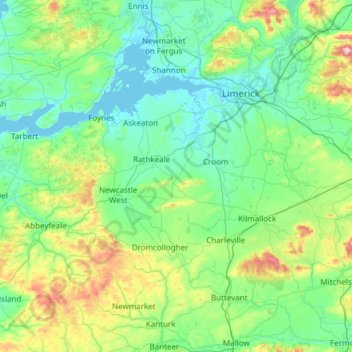
Name: County Limerick topographic map, elevation, terrain.

Location: County Limerick, Munster, Ireland (52.28020 -9.36543 52.69629 -8.15637)

Average elevation: 107 m

Minimum elevation: -2 m

Maximum elevation: 688 m

One possible meaning for the county's name in Irish Luimneach is "the flat area"; this description is accurate as the land consists mostly of a fertile limestone plain. Moreover, the county is ringed by mountains: the Slieve Felims to the northeast, the Galtees to the southeast, the Ballyhoura Mountains to the south, and the Mullaghareirk Mountains to the southwest and west. The highest point in the county is located in its southeast corner at Galtymore (919 m), which separates Limerick from County Tipperary. Limerick shares the 3rd-highest county peak in Ireland with Tipperary. The county is not simply a plain, its topography consists of hills and ridges. The eastern part of the county is part of the Golden Vale, which is well known for dairy produce and consists of rolling low hills. This gives way to very flat land around the centre of the county, with the exception being Knockfierna at 288 m high. Towards the west, the Mullaghareirk Mountains (Mullach an Radhairc in Irish, roughly meaning "mountains of the view") push across the county offering extensive views east over the county and west into County Kerry.

Wikipedia (CC-BY-SA 3.0)

Other topographic maps

Click on a map to view its topography, its elevation and its terrain.

Dublin

Ireland > County Dublin

Dublin, County Dublin, Leinster, Ireland

Average elevation: 42 m

County Kerry

Ireland

County Kerry, Munster, Ireland

Average elevation: 123 m

Cork

Ireland > County Cork > Cork

Cork, County Cork, Munster, T12 T997, Ireland

Average elevation: 94 m

Ballyseedy Wood

Ireland > County Kerry

Ballyseedy Wood, Ballyseedy ED, Tralee Municipal District, County Kerry, Munster, Ireland

Average elevation: 20 m

Galway City

Ireland > Galway City

Galway, Galway City, County Galway, Connacht, H91 YD86, Ireland

Average elevation: 26 m

County Donegal

Ireland

County Donegal, Ulster, Ireland

Average elevation: 74 m

Gort

Ireland > County Galway

Gort, Loughrea Municipal District, County Galway, Connacht, H91 R5F9, Ireland

Average elevation: 27 m

Cloonkeenkerrill

Ireland > County Galway

Cloonkeenkerrill, Colmanstown ED, Ballinasloe Municipal District, County Galway, Connacht, Ireland

Average elevation: 88 m

Kilkenny

Ireland > County Kilkenny

Kilkenny, The Municipal District of Kilkenny City, County Kilkenny, Leinster, Ireland

Average elevation: 61 m

County Galway

Ireland

County Galway, Connacht, Ireland

Average elevation: 68 m

County Wicklow

Ireland

County Wicklow, Leinster, Ireland

Average elevation: 166 m

County Mayo

Ireland

County Mayo, Connacht, Ireland

Average elevation: 66 m

Colmanstown

Ireland > County Clare

Colmanstown, Killofin ED, West Clare Municipal District, County Clare, Munster, Ireland

Average elevation: 24 m

Cordarragh

Ireland > County Galway

Cordarragh, Headford ED, Tuam Municipal District, County Galway, Connacht, Ireland

Average elevation: 20 m

Comeragh

Ireland > County Waterford

Comeragh, The Municipal District of Comeragh, County Waterford, Munster, Ireland

Average elevation: 215 m

County Wexford

Ireland

County Wexford, Leinster, Ireland

Average elevation: 63 m

County Cork

Ireland

County Cork, Munster, Ireland

Average elevation: 78 m

Sligo

Ireland > County Sligo

Sligo, Sligo Municipal Borough District, County Sligo, Connacht, Ireland

Average elevation: 21 m

County Clare

Ireland

County Clare, Munster, Ireland

Average elevation: 67 m

Ballincollig

Ireland > County Cork > Cork

Ballincollig, Cork, County Cork, Munster, P31 TW88, Ireland

Average elevation: 62 m

Adare

Ireland > County Limerick > The Municipal District of Adare — Rathkeale

Adare, The Municipal District of Adare — Rathkeale, County Limerick, Munster, Ireland

Average elevation: 12 m

County Meath

Ireland

County Meath, Leinster, Ireland

Average elevation: 64 m

Lanesborough

Ireland > County Longford

Lanesborough, Ballymahon Municipal District, County Longford, Leinster, Ireland

Average elevation: 41 m

Summerhill

Ireland > County Meath

Summerhill, Summerhill ED, The Municipal District of Trim, County Meath, Leinster, Ireland

Average elevation: 86 m

Curraghboy

Ireland > County Roscommon

Curraghboy, Rockhill Electoral Division, Athlone Municipal District, County Roscommon, Connacht, N37 EK20, Ireland

Average elevation: 69 m

Kilcurriv Eighter

Ireland > County Galway

Kilcurriv Eighter, Killower ED, Tuam Municipal District, County Galway, Connacht, Ireland

Average elevation: 48 m

Cahir

Ireland > County Tipperary

Cahir, The Municipal District of Cahir — Cashel, County Tipperary, Munster, Ireland

Average elevation: 58 m

Callanagh Lower

Ireland > County Cavan

Callanagh Lower, Drumlumman ED, Ballyjamesduff Municipal District, County Cavan, Ulster, Ireland

Average elevation: 85 m

Mount Lucas

Ireland > County Offaly

Mount Lucas, Esker ED, The Municipal District of Edenderry, County Offaly, Leinster, R35 XW10, Ireland

Average elevation: 76 m

Gorteennakilla

Ireland > County Tipperary

Gorteennakilla, Youghalarra, The Municipal District of Nenagh, County Tipperary, Munster, Ireland

Average elevation: 57 m

Lettermore

Ireland > County Galway

Lettermore, Lettermore ED, Conamara Municipal District, County Galway, Connacht, Ireland

Average elevation: 8 m

Ballyhaunis

Ireland > County Mayo

Ballyhaunis, Claremorris-Swinford Municipal District, County Mayo, Connacht, F35 NF82, Ireland

Average elevation: 87 m

Lough Bane

Ireland > County Westmeath

Lough Bane, Crosskeys ED, The Municipal District of Kells, County Westmeath, County Meath, Leinster, Ireland

Average elevation: 130 m

Upper Lough Bray

Ireland > County Wicklow

Upper Lough Bray, Powerscourt ED, The Municipal District of Bray, County Wicklow, Leinster, Ireland

Average elevation: 496 m

Broadlough

Ireland > County Louth

Broadlough, Ardee Rural ED, The Municipal District of Ardee, County Louth, Leinster, Ireland

Average elevation: 34 m

Moorock

Ireland > County Offaly

Moorock, Ballycumber ED, The Municipal District of Tullamore, County Offaly, Leinster, Ireland

Average elevation: 64 m

Barnadown

Ireland > County Kilkenny

Barnadown, Aghaviller, The Municipal District of Callan — Thomastown, County Kilkenny, Leinster, Ireland

Average elevation: 212 m

Shronowen

Ireland > County Kerry

Shronowen, Shronowen ED, Listowel Municipal District, County Kerry, Munster, Ireland

Average elevation: 27 m

Pembrokestown

Ireland > County Waterford

Pembrokestown, Waterford City Metropolitan District, County Waterford, Munster, X91 R6CA, Ireland

Average elevation: 57 m

Smithstown

Ireland > County Meath

Smithstown, Ballinlough ED, The Municipal District of Kells, County Meath, Leinster, Ireland

Average elevation: 121 m

County Waterford

Ireland > County Waterford

County Waterford, Munster, Ireland

Average elevation: 86 m

Ballinaclogh

Ireland > County Wicklow

Ballinaclogh, Glenealy ED, The Municipal District of Wicklow, County Wicklow, Leinster, Ireland

Average elevation: 108 m

Pollduff

Ireland > County Galway

Pollduff, Loughrea Municipal District, County Galway, Connacht, Ireland

Average elevation: 219 m

Kiltole

Ireland > County Donegal

Kiltole, Figart ED, Lifford-Stranorlar Municipal District, County Donegal, Ireland

Average elevation: 49 m

Durrow

Ireland > County Offaly

Durrow, The Municipal District of Tullamore, County Offaly, Leinster, R35 X865, Ireland

Average elevation: 66 m

Inchigeelagh

Ireland > County Cork

Inchigeelagh, Municipal District of Macroom, County Cork, Munster, P12 W864, Ireland

Average elevation: 135 m

Aghafin

Ireland > County Roscommon

Aghafin, Aghafin ED, Boyle Municipal District, County Roscommon, Connacht, Ireland

Average elevation: 50 m

Cloonmore

Ireland > County Galway

Cloonmore, Belclare ED, Tuam Municipal District, County Galway, Connacht, Ireland

Average elevation: 33 m

Priorswood

Ireland > County Dublin > Dublin

Priorswood, Priorswood E Ward 1986, Dublin, County Dublin, Leinster, D17 XV48, Ireland

Average elevation: 42 m

Ballyboughal

Ireland > County Dublin

Ballyboughal, Ballyboghil DED 1986, Fingal, County Dublin, Leinster, Ireland

Average elevation: 35 m