
Czechia topographic map
Interactive map
Click on the map to display elevation.
Czechia
Temperatures vary depending on the elevation. In general, at higher altitudes, the temperatures decrease and precipitation increases. The wettest area in the Czech Republic is found around Bílý Potok in Jizera Mountains and the driest region is the Louny District to the northwest of Prague. Another factor is the distribution of the mountains.
About this map
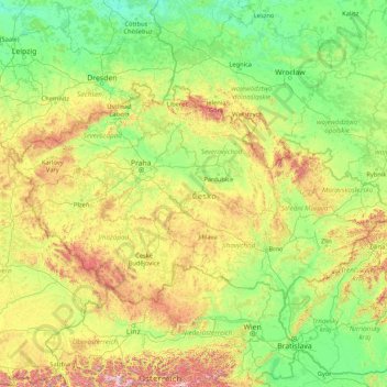
Name: Czechia topographic map, elevation, terrain.
Location: Czechia (48.55181 12.09058 51.05570 18.85925)
Average elevation: 369 m
Minimum elevation: 47 m
Maximum elevation: 2,335 m
Other topographic maps
Click on a map to view its topography, its elevation and its terrain.
Europe
Europe's topography is characterized by a striking contrast between its rugged southern mountains and the expansive plains of the north. The continent is often described as a "peninsula of peninsulas," featuring major peninsulas like the Iberian, Italian, and Balkan, each with unique geological features. In…
Average elevation: 223 m
Tbilisi
Most of the raions are named after historic quarters of the city. The citizens of Tbilisi widely recognise an informal system of smaller historic neighbourhoods. Such neighbourhoods are several, however, constituting a kind of hierarchy, because most of them have lost their distinctive topographic limits. The…
Average elevation: 713 m
Seis am Schlern - Siusi allo Sciliar
Italy > Trentino – Alto Adige/Südtirol > South Tyrol > Kastelruth - Castelrotto
Average elevation: 1,211 m
Dibai
India > Uttar Pradesh > Debai
Dibai is located at 28°13′N 78°15′E / 28.22°N 78.25°E / 28.22; 78.25. It has an average elevation of 184 metres (603 feet).
Average elevation: 190 m
Genting Highlands
Genting Highlands is a hill station located on the peak of Mount Ulu Kali in the Titiwangsa Mountains, central Peninsular Malaysia, at 1800 metres elevation. Located in the state of Pahang, it was established in 1965 by the late Malaysian businessman Lim Goh Tong. The primary tourist attraction is Resorts…
Average elevation: 1,517 m
Sorsogon City
Sorsogon City covers a land area of 31,292 hectares (120.82 sq mi). It is at the southernmost tip of the Bicol Peninsula and of Luzon Island. The city is bounded by Castilla in the west, Manito in the northwest, Albay Gulf in the north, Prieto Diaz in the east, Gubat in the southeast, Casiguran in the…
Average elevation: 89 m
San Cristóbal
Mexico > Chiapas > San Cristóbal de las Casas
The city and municipality are located in a region called the Chiapas Highlands or Central Highlands. Two thirds of the municipality is made up of mountainous terrain with the rest valley floor. The city proper is located at 2,200 meters above sea level in a small valley surrounded by hills. The most important…
Average elevation: 2,038 m
State Line
United States > Pennsylvania > Bedford County > Londonderry Township
Average elevation: 329 m
Tatarevina
Bosnia and Herzegovina > Republika Srpska > Town of Prnjavor > Doline
Average elevation: 172 m
Monterrey
Mexico > Nuevo León > Monterrey
The city of Monterrey is 540 metres (1,770 ft) above sea level in the northeastern state of Nuevo León. Monterrey translated literally from Spanish to English is "King Mount" or "King Mountain", and folk etymology claims that this refers to the city's topography and the large mountains that surround it…
Average elevation: 753 m
Source du Mirail
France > Provence-Alpes-Côte d'Azur > Vaucluse > Peypin-d'Aigues
Average elevation: 493 m
Harare
Harare (/həˈrɑːreɪ/; formerly Salisbury /ˈsɔːlzbəri/) is the capital and most populous city of Zimbabwe. The city proper has an area of 940 km2 (371 mi2) and a population of 2.12 million in the 2012 census and an estimated 3.12 million in its metropolitan area in 2019. Situated in north-eastern…
Average elevation: 1,470 m
Bsharri
Bsharri (Arabic: بشرّي Bšarrī; also romanized Becharre, Bcharre, Bsharre, Bcharre Al Arz) is a Lebanese town located in the district of the same name, North Governorate, situated at altitudes between 1,100 m (3,600 ft) and 3,088 m (10,131 ft). Bsharri is the location of the Cedars of God, a UNESCO World…
Average elevation: 1,847 m
Woss
Canada > British Columbia > Regional District of Mount Waddington > Area D (Nimpkish Valley/Cormorant Island)
Average elevation: 201 m
Uppala
India > Kerala > Manjeswaram
Uppala is located near the Arabian Sea, and has a very low elevation of nine metres. The town is densely populated near the National Highway 66.
Average elevation: 15 m
Bay Road Park
United Kingdom > Northern Ireland > County Londonderry > Derry/Londonderry
Average elevation: 19 m
South America
One of the earliest known South American civilizations was Caral–Supe, on the central Peruvian coast. Though a pre-ceramic culture, the monumental architecture of Caral–Supe created one of the first cities of the world, generally dated to around 3500 BC, at Huaricanga in the Fortaleza area, contemporaneous…
Average elevation: 283 m
Ashes Pasture
United Kingdom > England > North Yorkshire > Horton in Ribblesdale
Average elevation: 315 m
Waipahu
United States > Hawaii > Honolulu County
There are several streams that run through Waipahu, including Waikele Stream and Kapakahi Stream. Waikele Stream runs along the Hawaii Plantation Village and down into Pouhala Marsh Wildlife Sanctuary, which is habitat for several endangered bird species that are endemic to Hawaii. There is roughly 140 feet of…
Average elevation: 164 m