Geolocate

County Dublin topographic map

Interactive map

Click on the map to display elevation.

About this map

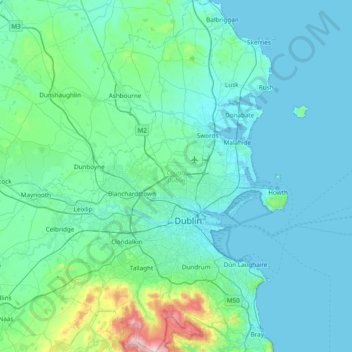
Name: County Dublin topographic map, elevation, terrain.

Location: County Dublin, Leinster, Ireland (53.17826 -6.54689 53.63471 -5.99450)

Average elevation: 71 m

Minimum elevation: -1 m

Maximum elevation: 733 m

Dublin is a topographically varied region. The city centre is generally very low-lying, and many areas of coastal Dublin are at or near sea-level. In the south of the county, the topography rises steeply from sea-level at the coast to over 500 metres (1,600 ft) in just a few kilometres. This natural barrier has resulted in densely populated coastal settlements in Dún Laoghaire–Rathdown and westward urban sprawl in South Dublin. In contrast, Fingal is generally rural in nature and much less densely populated than the rest of the county. Consequently, Fingal is significantly larger than the other three local authorities and covers about 49.5% of County Dublin's land area. Fingal is also perhaps the flattest region in Ireland, with the low-lying Naul Hills rising to a maximum height of just 176 metres (577 ft).

Wikipedia (CC-BY-SA 3.0)

Other topographic maps

Click on a map to view its topography, its elevation and its terrain.

Dublin

Ireland > County Dublin

Dublin, County Dublin, Leinster, Ireland

Average elevation: 42 m

Cork

Ireland > County Cork > Cork

Cork, County Cork, Munster, T12 T997, Ireland

Average elevation: 94 m

County Waterford

Ireland > County Waterford

County Waterford, Munster, Ireland

Average elevation: 86 m

County Kerry

Ireland

County Kerry, Munster, Ireland

Average elevation: 123 m

County Mayo

Ireland

County Mayo, Connacht, Ireland

Average elevation: 66 m

County Wexford

Ireland

County Wexford, Leinster, Ireland

Average elevation: 63 m

Galway City

Ireland > Galway City

Galway, Galway City, County Galway, Connacht, H91 YD86, Ireland

Average elevation: 26 m

Ballybrack

Ireland > County Donegal

Ballybrack, Moville ED, Inishowen Municipal District, County Donegal, Ireland

Average elevation: 147 m

Conaghy

Ireland > County Monaghan

Conaghy, Killeevan ED, Ballybay-Clones Municipal District, County Monaghan, Ulster, Ireland

Average elevation: 67 m

Ballyseedy Wood

Ireland > County Kerry

Ballyseedy Wood, Ballyseedy ED, Tralee Municipal District, County Kerry, Munster, Ireland

Average elevation: 20 m

Glenfarne

Ireland > County Leitrim

Glenfarne, Glenfarn ED, Manorhamilton Municipal District, County Leitrim, Connacht, Ireland

Average elevation: 90 m

Johnstown

Ireland > County Kildare

Johnstown, The Municipal District of Naas, County Kildare, Leinster, W91 Y3CP, Ireland

Average elevation: 97 m

County Galway

Ireland

County Galway, Connacht, Ireland

Average elevation: 68 m

County Donegal

Ireland

County Donegal, Ulster, Ireland

Average elevation: 74 m

Moyglare

Ireland > County Meath

Moyglare, Rodanstown ED, The Municipal District of Ratoath, County Meath, Leinster, W23 RT91, Ireland

Average elevation: 66 m

Gort

Ireland > County Galway

Gort, Loughrea Municipal District, County Galway, Connacht, H91 R5F9, Ireland

Average elevation: 27 m

Cloonkeenkerrill

Ireland > County Galway

Cloonkeenkerrill, Colmanstown ED, Ballinasloe Municipal District, County Galway, Connacht, Ireland

Average elevation: 88 m

Kilkenny

Ireland > County Kilkenny

Kilkenny, The Municipal District of Kilkenny City, County Kilkenny, Leinster, Ireland

Average elevation: 61 m

County Limerick

Ireland

County Limerick, Munster, Ireland

Average elevation: 107 m

Sligo

Ireland > County Sligo

Sligo, Sligo Municipal Borough District, County Sligo, Connacht, Ireland

Average elevation: 21 m

Dromore West

Ireland > County Sligo

Dromore West, Ballymote-Tubbercurry Municipal District, County Sligo, Connacht, Ireland

Average elevation: 51 m

Morristown

Ireland > County Kildare

Morristown, Rathmore ED, The Municipal District of Naas, County Kildare, Leinster, Ireland

Average elevation: 113 m

County Wicklow

Ireland

County Wicklow, Leinster, Ireland

Average elevation: 166 m

Colmanstown

Ireland > County Clare

Colmanstown, Killofin ED, West Clare Municipal District, County Clare, Munster, Ireland

Average elevation: 24 m

County Clare

Ireland

County Clare, Munster, Ireland

Average elevation: 67 m

Ballincollig

Ireland > County Cork > Cork

Ballincollig, Cork, County Cork, Munster, P31 TW88, Ireland

Average elevation: 62 m

Cordarragh

Ireland > County Galway

Cordarragh, Headford ED, Tuam Municipal District, County Galway, Connacht, Ireland

Average elevation: 20 m

Comeragh

Ireland > County Waterford

Comeragh, The Municipal District of Comeragh, County Waterford, Munster, Ireland

Average elevation: 215 m

Adare

Ireland > County Limerick > The Municipal District of Adare — Rathkeale

Adare, The Municipal District of Adare — Rathkeale, County Limerick, Munster, Ireland

Average elevation: 12 m

Smithstown

Ireland > County Meath

Smithstown, Ballinlough ED, The Municipal District of Kells, County Meath, Leinster, Ireland

Average elevation: 121 m

County Cork

Ireland

County Cork, Munster, Ireland

Average elevation: 78 m

County Meath

Ireland

County Meath, Leinster, Ireland

Average elevation: 64 m

Cahir

Ireland > County Tipperary

Cahir, The Municipal District of Cahir — Cashel, County Tipperary, Munster, Ireland

Average elevation: 58 m

Lanesborough

Ireland > County Longford

Lanesborough, Ballymahon Municipal District, County Longford, Leinster, Ireland

Average elevation: 41 m

Curraghboy

Ireland > County Roscommon

Curraghboy, Rockhill Electoral Division, Athlone Municipal District, County Roscommon, Connacht, N37 EK20, Ireland

Average elevation: 69 m

Ballivor

Ireland > County Meath

Ballivor, The Municipal District of Trim, County Meath, Leinster, Ireland

Average elevation: 67 m

Lough Bane

Ireland > County Westmeath

Lough Bane, Crosskeys ED, The Municipal District of Kells, County Westmeath, County Meath, Leinster, Ireland

Average elevation: 130 m

Summerhill

Ireland > County Meath

Summerhill, Summerhill ED, The Municipal District of Trim, County Meath, Leinster, Ireland

Average elevation: 86 m

Gorteennakilla

Ireland > County Tipperary

Gorteennakilla, Youghalarra, The Municipal District of Nenagh, County Tipperary, Munster, Ireland

Average elevation: 57 m

Barnadown

Ireland > County Kilkenny

Barnadown, Aghaviller, The Municipal District of Callan — Thomastown, County Kilkenny, Leinster, Ireland

Average elevation: 212 m

Kilcurriv Eighter

Ireland > County Galway

Kilcurriv Eighter, Killower ED, Tuam Municipal District, County Galway, Connacht, Ireland

Average elevation: 48 m

Callanagh Lower

Ireland > County Cavan

Callanagh Lower, Drumlumman ED, Ballyjamesduff Municipal District, County Cavan, Ulster, Ireland

Average elevation: 85 m

Ballyhaunis

Ireland > County Mayo

Ballyhaunis, Claremorris-Swinford Municipal District, County Mayo, Connacht, F35 NF82, Ireland

Average elevation: 87 m

Mount Lucas

Ireland > County Offaly

Mount Lucas, Esker ED, The Municipal District of Edenderry, County Offaly, Leinster, R35 XW10, Ireland

Average elevation: 76 m

Broadlough

Ireland > County Louth

Broadlough, Ardee Rural ED, The Municipal District of Ardee, County Louth, Leinster, Ireland

Average elevation: 34 m

Moorock

Ireland > County Offaly

Moorock, Ballycumber ED, The Municipal District of Tullamore, County Offaly, Leinster, Ireland

Average elevation: 64 m

Shronowen

Ireland > County Kerry

Shronowen, Shronowen ED, Listowel Municipal District, County Kerry, Munster, Ireland

Average elevation: 27 m

Pembrokestown

Ireland > County Waterford

Pembrokestown, Waterford City Metropolitan District, County Waterford, Munster, X91 R6CA, Ireland

Average elevation: 57 m

Lettermore

Ireland > County Galway

Lettermore, Lettermore ED, Conamara Municipal District, County Galway, Connacht, Ireland

Average elevation: 8 m

Ballinaclogh

Ireland > County Wicklow

Ballinaclogh, Glenealy ED, The Municipal District of Wicklow, County Wicklow, Leinster, Ireland

Average elevation: 108 m