
Chattogram Division topographic map
Interactive map
Click on the map to display elevation.
About this map
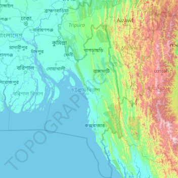
Name: Chattogram Division topographic map, elevation, terrain.
Location: Chattogram Division, Bangladesh (20.36791 90.53934 24.27645 92.68030)
Average elevation: 297 m
Minimum elevation: -2 m
Maximum elevation: 2,985 m
Other topographic maps
Click on a map to view its topography, its elevation and its terrain.
Sajek Valley - সাজেক ভ্যালি / মেঘের উপত্যকায় জীবন
Bangladesh > Chattogram Division > Bagaichhari Upazila > Sajek
Average elevation: 256 m
Rangamati
Bangladesh > Chattogram Division > Rangamati Sadar Upazila
Rangamati (Bengali: রাঙ্গামাটি is the administrative headquarter and town of Rangamati District in the Chittagong Hill Tracts of Bangladesh. The town is located at 22°37'60N 92°12'0E and has an altitude of 14 metres (46 ft). It was the capital of the Chakma kingdom during the British rule…
Average elevation: 68 m
Brahmaputra River
Bangladesh > Mymensingh Division > Jamalpur Sadar Upazila > Jamalpur
The course of the Brahmaputra River has changed drastically in the past two and a half centuries, moving its river course westwards for a distance of about 80 km (50 mi), leaving its old river course, appropriately named the old Brahmaputra river, behind. In the past, the floodplain of the old river course had…
Average elevation: 18 m
Cox's Bazar
Bangladesh > Chattogram Division > Cox's Bazar District > Cox's Bazar
Cox's Bazar lies on a coastal plain in the southeastern corner of Bangladesh. From above, the plain appears to bulge out into the Bay of Bengal. Along the shore is an extensive area of beach and dunes. Most of the city is built on a floodplain that is lower in elevation than the dunes, making it more…
Average elevation: 13 m
Mymensingh
Bangladesh > Mymensingh Division > Mymensingh
Mymensingh is the 8th administrative divisional headquarter and 12th city corporation of Bangladesh. According to Ministry of Public Administration, Mymensingh is ranked 4th in district status. The density of Mymensingh city is 44,458/km2 (115,150/sq mi) which is the second most densely populated city in…
Average elevation: 14 m