
Make a donation
Gear up for your next adventure:
As an Amazon Associate, this site earns from qualifying purchases at no extra cost to you.
Furry Glen topographic map
Click on the map to display elevation.
Make a donation
Gear up for your next adventure:
As an Amazon Associate, this site earns from qualifying purchases at no extra cost to you.
About this map
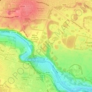
Name: Furry Glen topographic map, elevation, terrain.
Average elevation: 44 m
Minimum elevation: 4 m
Maximum elevation: 75 m
Ireland trails, hiking, mountain biking, running and outdoor activities
Make a donation
Gear up for your next adventure:
As an Amazon Associate, this site earns from qualifying purchases at no extra cost to you.
Other topographic maps
Click on a map to view its topography, its elevation and its terrain.
Make a donation
Gear up for your next adventure:
As an Amazon Associate, this site earns from qualifying purchases at no extra cost to you.
County Wicklow
The county experiences a narrow annual temperature range. Typical daytime highs range from 17–22 °C (63–72 °F) throughout the county in July and August, with overnight lows in the 11–14 °C (52–57 °F) range, although temperatures in the mountains can be 5–10 °C (41–50 °F) lower. Mean January…
Average elevation: 166 m
County Kerry
Bounded by the Atlantic Ocean, Kerry is Ireland's most westerly county. Its rugged coastline stretches for 886 kilometres (551 miles) and is characterised by bays, sea cliffs, beaches and many small offshore islands, of which the Blaskets and the Skelligs are the most notable. The county's peninsulas have a…
Average elevation: 123 m
County Dublin
Dublin is a topographically varied region. The city centre is generally very low-lying, and many areas of coastal Dublin are at or near sea-level. In the south of the county, the topography rises steeply from sea-level at the coast to over 500 metres (1,600 ft) in just a few kilometres. This natural barrier…
Average elevation: 71 m
Make a donation
Gear up for your next adventure:
As an Amazon Associate, this site earns from qualifying purchases at no extra cost to you.
Cork
The climate of Cork, like the majority of Ireland, is mild oceanic (Cfb in the Köppen climate classification) and changeable with abundant rainfall and a lack of temperature extremes. Cork lies in plant Hardiness zone 9b. Met Éireann maintains a climatological weather station at Cork Airport, a few…
Average elevation: 79 m
County Meath
Meath is largely flat and much of the county lies below 100 m (330 ft) above sea-level. The minor hills in the far west of the county at Loughcrew, and in the north at Carrickleck are the only upland areas of any significance. Slieve na Calliagh, at just 276 m (906 ft) in height, is the highest point in the…
Average elevation: 64 m
County Cork
County Cork is located in the province of Munster, bordering Kerry to the west, Limerick to the north, Tipperary to the north-east and Waterford to the east. The county shares separate mountainous borders with Tipperary and Kerry. The terrain on the Kerry border was formed between 360 and 374 million years…
Average elevation: 78 m
Make a donation
Gear up for your next adventure:
As an Amazon Associate, this site earns from qualifying purchases at no extra cost to you.
Make a donation
Gear up for your next adventure:
As an Amazon Associate, this site earns from qualifying purchases at no extra cost to you.
County Kilkenny
The River Nore flows through the county and the River Suir forms the border with County Waterford. Brandon Hill is the highest point with an elevation of 515 m (1,690 ft). Most of the county has a hilly surface of moderate elevation with uplands in the north-east, the north-west and the South of the county;…
Average elevation: 120 m
Make a donation
Gear up for your next adventure:
As an Amazon Associate, this site earns from qualifying purchases at no extra cost to you.
Make a donation
Gear up for your next adventure:
As an Amazon Associate, this site earns from qualifying purchases at no extra cost to you.
County Donegal
The majority of Donegal has a temperate oceanic climate (Köppen climate classification: Cfb), with upland areas in the Derryveagh and Blue Stack ranges classified as oceanic subpolar (Köppen climate classification: Cfc). The county's climate is heavily influenced by the North Atlantic Current. Due to the…
Average elevation: 73 m
Make a donation
Gear up for your next adventure:
As an Amazon Associate, this site earns from qualifying purchases at no extra cost to you.
County Limerick
One possible meaning for the county's name in Irish Luimneach is "the flat area"; this description is accurate as the land consists mostly of a fertile limestone plain. Moreover, the county is ringed by mountains: the Slieve Felims to the northeast, the Galtees to the southeast, the Ballyhoura Mountains to the…
Average elevation: 107 m
Make a donation
Gear up for your next adventure:
As an Amazon Associate, this site earns from qualifying purchases at no extra cost to you.
Make a donation
Gear up for your next adventure:
As an Amazon Associate, this site earns from qualifying purchases at no extra cost to you.
Make a donation
Gear up for your next adventure:
As an Amazon Associate, this site earns from qualifying purchases at no extra cost to you.
Make a donation
Gear up for your next adventure:
As an Amazon Associate, this site earns from qualifying purchases at no extra cost to you.
Make a donation
Gear up for your next adventure:
As an Amazon Associate, this site earns from qualifying purchases at no extra cost to you.
Make a donation
Gear up for your next adventure:
As an Amazon Associate, this site earns from qualifying purchases at no extra cost to you.
Make a donation
Gear up for your next adventure:
As an Amazon Associate, this site earns from qualifying purchases at no extra cost to you.
Make a donation
Gear up for your next adventure:
As an Amazon Associate, this site earns from qualifying purchases at no extra cost to you.
Make a donation
Gear up for your next adventure:
As an Amazon Associate, this site earns from qualifying purchases at no extra cost to you.
Make a donation
Gear up for your next adventure:
As an Amazon Associate, this site earns from qualifying purchases at no extra cost to you.
Make a donation
Gear up for your next adventure:
As an Amazon Associate, this site earns from qualifying purchases at no extra cost to you.
Make a donation
Gear up for your next adventure:
As an Amazon Associate, this site earns from qualifying purchases at no extra cost to you.
Make a donation
Gear up for your next adventure:
As an Amazon Associate, this site earns from qualifying purchases at no extra cost to you.
Make a donation
Gear up for your next adventure:
As an Amazon Associate, this site earns from qualifying purchases at no extra cost to you.
Make a donation
Gear up for your next adventure:
As an Amazon Associate, this site earns from qualifying purchases at no extra cost to you.
Make a donation
Gear up for your next adventure:
As an Amazon Associate, this site earns from qualifying purchases at no extra cost to you.
Make a donation
Gear up for your next adventure:
As an Amazon Associate, this site earns from qualifying purchases at no extra cost to you.
Make a donation
Gear up for your next adventure:
As an Amazon Associate, this site earns from qualifying purchases at no extra cost to you.