
Gujarat topographic map
Interactive map
Click on the map to display elevation.
About this map
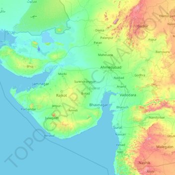
Name: Gujarat topographic map, elevation, terrain.
Location: Gujarat, India (20.11953 68.18562 24.71189 74.47643)
Average elevation: 137 m
Minimum elevation: -5 m
Maximum elevation: 1,595 m
Other topographic maps
Click on a map to view its topography, its elevation and its terrain.
Srinivasapuram
India > Telangana > Huzur nagar mandal
Srinivasapuram, Huzur nagar mandal, Suryapet District, Telangana, India
Average elevation: 104 m
Arasikere
India > Karnataka > Arasikere taluku
Arasikere, Arasikere taluku, Hassan District, Karnataka, 573103, India
Average elevation: 835 m
Sangareddy
India > Telangana > Sangareddy mandal
Sangareddy, Sangareddy mandal, Sangareddy District, Telangana, 502001, India
Average elevation: 517 m
Kodaikanal
Kodaikanal, Dindigul District, Tamil Nadu, India
Average elevation: 869 m
Majri
India > Punjab > Samana Tahsil
Majri, Samana Tahsil, Patiala District, Punjab, India
Average elevation: 244 m
Samana
India > Madhya Pradesh > Devendranagar Tahsil > Samana
Samana, Devendranagar Tahsil, Panna District, Madhya Pradesh, India
Average elevation: 326 m
Kawant
India > Gujarat > Kavant Taluka
Kawant, Kavant Taluka, Chhota Udaipur District, Gujarat, 391170, India
Average elevation: 200 m
Kishorganj
India > Madhya Pradesh > Rajnagar Tahsil > Bamitha
Kishorganj, Bamitha, Rajnagar Tahsil, Chhatarpur District, Madhya Pradesh, India
Average elevation: 245 m
Perumpetty
India > Kerala > Mallappally
Perumpetty, Mallappally, Pathanamthitta District, Kerala, India
Average elevation: 89 m
Kameswaram
India > Tamil Nadu > Kilvelur
Kameswaram, Kilvelur, Nagapattinam District, Tamil Nadu, 611110, India
Average elevation: 2 m
Bengaluru
India > Karnataka > Bangalore North
Bengaluru, Bangalore North, Bangalore Urban, Karnataka, India
Average elevation: 881 m
Puducherry
India > Puducherry > Puducherry Taluk
Puducherry, Puducherry Taluk, Puducherry District, Puducherry, 605001, India
Average elevation: 10 m
Badrinath
India > Uttarakhand > Joshimath Tehsil
Badrinath, Joshimath Tehsil, Chamoli District, Uttarakhand, India
Average elevation: 4,052 m
Faridpur
Faridpur, Bareilly District, Uttar Pradesh, India
Average elevation: 164 m
Barmer
India > Rajasthan > Barmer Tehsil
Barmer, Barmer Tehsil, Barmer District, Rajasthan, 344001, India
Average elevation: 188 m
Dubli
India > Madhya Pradesh > Tarana Tahsil > Dubli
Dubli, Tarana Tahsil, Ujjain District, Madhya Pradesh, India
Average elevation: 494 m
Mokila
India > Telangana > Shankarpalle mandal
Mokila, Shankarpalle mandal, Ranga Reddy District, Telangana, India
Average elevation: 569 m
Udaipur
Udaipur, Lahul and Spiti, Himachal Pradesh, India
Average elevation: 4,552 m
Koduvally
India > Kerala > Thamarassery
Koduvally, Thamarassery, Kozhikode district, Kerala, 673572, India
Average elevation: 41 m
Boys Company
India > Tamil Nadu > Coonoor
Boys Company, Coonoor, The Nilgiris District, Tamil Nadu, 643231, India
Average elevation: 1,881 m
Pykara
India > Tamil Nadu > Udhagamandalam
Pykara, Udhagamandalam, The Nilgiris District, Tamil Nadu, India
Average elevation: 2,104 m
Gudalur
Gudalur, The Nilgiris District, Tamil Nadu, India
Average elevation: 1,133 m
Bareilly
Bareilly, Bareilly District, Uttar Pradesh, India
Average elevation: 172 m
Kundalika Valley view point
India > Maharashtra > Mulshi > Pimpri
Kundalika Valley view point, Andharban Trail, Pimpri, Mulshi, Pune, Maharashtra, India
Average elevation: 679 m
Leh
India > Ladakh > Leh Tehsil
Leh, Leh Tehsil, Leh district, Ladakh, India
Average elevation: 3,653 m
Vattappara
India > Kerala > Nedumangad
Vattappara, Nedumangad, Thiruvananthapuram, Kerala, 695028, India
Average elevation: 87 m
Hyati
India > Karnataka > Koppala taluku
Hyati, Koppala taluku, Koppal district, Karnataka, India
Average elevation: 509 m
Sahibzada Ajit Singh Nagar
Sahibzada Ajit Singh Nagar, Punjab, India
Average elevation: 311 m