
Chandigarh topographic map
Interactive map
Click on the map to display elevation.
About this map
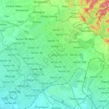
Name: Chandigarh topographic map, elevation, terrain.
Location: Chandigarh, India (30.66497 76.70499 30.79495 76.84903)
Average elevation: 343 m
Minimum elevation: 300 m
Maximum elevation: 511 m
Chandigarh is located by the foothills of the Shivalik Range of the Himalayas in northwest India. It covers an area of approximately 114 km2. It borders the states of Punjab and Haryana. The exact geographic coordinates of Chandigarh are 30°44′N 76°47′E / 30.74°N 76.79°E / 30.74; 76.79. It has an average elevation of 321 metres (1053 ft).
Other topographic maps
Click on a map to view its topography, its elevation and its terrain.
Krishnapur
India > Maharashtra > Chandurbazar
Krishnapur, Chandurbazar, Amravati District, Maharashtra, India
Average elevation: 348 m
Srinivasapuram
India > Telangana > Huzur nagar mandal
Srinivasapuram, Huzur nagar mandal, Suryapet District, Telangana, India
Average elevation: 104 m
Kodaikanal
Kodaikanal, Dindigul District, Tamil Nadu, India
Average elevation: 869 m
Arasikere
India > Karnataka > Arasikere taluku
Arasikere, Arasikere taluku, Hassan District, Karnataka, 573103, India
Average elevation: 835 m
Sangareddy
India > Telangana > Sangareddy mandal
Sangareddy, Sangareddy mandal, Sangareddy District, Telangana, 502001, India
Average elevation: 517 m
Majri
India > Punjab > Samana Tahsil
Majri, Samana Tahsil, Patiala District, Punjab, India
Average elevation: 244 m
Samana
India > Madhya Pradesh > Devendranagar Tahsil > Samana
Samana, Devendranagar Tahsil, Panna District, Madhya Pradesh, India
Average elevation: 326 m
Kawant
India > Gujarat > Kavant Taluka
Kawant, Kavant Taluka, Chhota Udaipur District, Gujarat, 391170, India
Average elevation: 200 m
Kishorganj
India > Madhya Pradesh > Rajnagar Tahsil > Bamitha
Kishorganj, Bamitha, Rajnagar Tahsil, Chhatarpur District, Madhya Pradesh, India
Average elevation: 245 m
Perumpetty
India > Kerala > Mallappally
Perumpetty, Mallappally, Pathanamthitta District, Kerala, India
Average elevation: 89 m
Kameswaram
India > Tamil Nadu > Kilvelur
Kameswaram, Kilvelur, Nagapattinam District, Tamil Nadu, 611110, India
Average elevation: 2 m
Bengaluru
India > Karnataka > Bangalore North
Bengaluru, Bangalore North, Bangalore Urban, Karnataka, India
Average elevation: 881 m
Puducherry
India > Puducherry > Puducherry Taluk
Puducherry, Puducherry Taluk, Puducherry District, Puducherry, 605001, India
Average elevation: 10 m
Badrinath
India > Uttarakhand > Joshimath Tehsil
Badrinath, Joshimath Tehsil, Chamoli District, Uttarakhand, India
Average elevation: 4,052 m
Faridpur
Faridpur, Bareilly District, Uttar Pradesh, India
Average elevation: 164 m
Barmer
India > Rajasthan > Barmer Tehsil
Barmer, Barmer Tehsil, Barmer District, Rajasthan, 344001, India
Average elevation: 188 m
Dubli
India > Madhya Pradesh > Tarana Tahsil > Dubli
Dubli, Tarana Tahsil, Ujjain District, Madhya Pradesh, India
Average elevation: 494 m
Mokila
India > Telangana > Shankarpalle mandal
Mokila, Shankarpalle mandal, Ranga Reddy District, Telangana, India
Average elevation: 569 m
Udaipur
Udaipur, Lahul and Spiti, Himachal Pradesh, India
Average elevation: 4,552 m
Koduvally
India > Kerala > Thamarassery
Koduvally, Thamarassery, Kozhikode district, Kerala, 673572, India
Average elevation: 41 m
Boys Company
India > Tamil Nadu > Coonoor
Boys Company, Coonoor, The Nilgiris District, Tamil Nadu, 643231, India
Average elevation: 1,881 m
Pykara
India > Tamil Nadu > Udhagamandalam
Pykara, Udhagamandalam, The Nilgiris District, Tamil Nadu, India
Average elevation: 2,104 m
Gudalur
Gudalur, The Nilgiris District, Tamil Nadu, India
Average elevation: 1,133 m
Bareilly
Bareilly, Bareilly District, Uttar Pradesh, India
Average elevation: 172 m
Kundalika Valley view point
India > Maharashtra > Mulshi > Pimpri
Kundalika Valley view point, Andharban Trail, Pimpri, Mulshi, Pune, Maharashtra, India
Average elevation: 679 m
Leh
India > Ladakh > Leh Tehsil
Leh, Leh Tehsil, Leh district, Ladakh, India
Average elevation: 3,653 m
Vattappara
India > Kerala > Nedumangad
Vattappara, Nedumangad, Thiruvananthapuram, Kerala, 695028, India
Average elevation: 87 m
Hyati
India > Karnataka > Koppala taluku
Hyati, Koppala taluku, Koppal district, Karnataka, India
Average elevation: 509 m
Sahibzada Ajit Singh Nagar
Sahibzada Ajit Singh Nagar, Punjab, India
Average elevation: 311 m