
Puerto del Aire topographic map
Interactive map
Click on the map to display elevation.
About this map
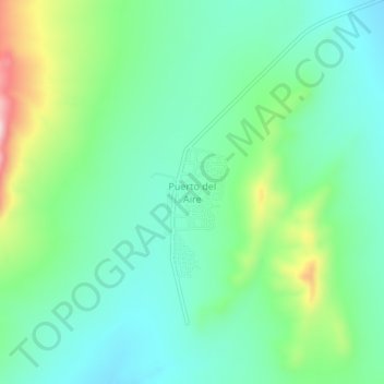
Name: Puerto del Aire topographic map, elevation, terrain.
Location: Puerto del Aire, Doctor Arroyo, Nuevo León, México (23.34822 -100.44695 23.38822 -100.40695)
Average elevation: 1,858 m
Minimum elevation: 1,772 m
Maximum elevation: 2,081 m
Other topographic maps
Click on a map to view its topography, its elevation and its terrain.
Los Cuartos
México > Nuevo León > Doctor Arroyo
Los Cuartos, Doctor Arroyo, Nuevo León, México
Average elevation: 1,843 m
Puerto de Dolores
México > Nuevo León > Doctor Arroyo > Puerto de Dolores
Puerto de Dolores, Doctor Arroyo, Nuevo León, México
Average elevation: 1,762 m