
Sfax topographic map
Interactive map
Click on the map to display elevation.
About this map
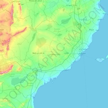
Name: Sfax topographic map, elevation, terrain.
Location: Sfax, Tunisia (34.16803 9.71110 35.27851 11.36328)
Average elevation: 93 m
Minimum elevation: -3 m
Maximum elevation: 815 m
Other topographic maps
Click on a map to view its topography, its elevation and its terrain.
Bizerte
Tunisia > Bizerte > بوبكر باكير
The bridge leads to the motorway A4 leading to Tunis–Carthage International Airport and the capital. On the town side the P11 passes semi-rural Louata, hugs Ichkeul Lake and branches into a western route, the P7, leading directly to Tabarka on the coast next to the Algerian border. The P11 leads south-west…
Average elevation: 28 m