
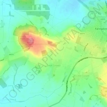
Great Coxwell topographic map
Interactive map
Click on the map to display elevation.
About this map
Name: Great Coxwell topographic map, elevation, terrain.
Average elevation: 108 m
Minimum elevation: 78 m
Maximum elevation: 174 m
Other topographic maps
Click on a map to view its topography, its elevation and its terrain.
Abingdon
United Kingdom > England > Oxfordshire > Vale of White Horse
Abingdon, Vale of White Horse, Oxfordshire, England, OX14 3UJ, United Kingdom
Average elevation: 64 m
Little Coxwell
United Kingdom > England > Oxfordshire > Vale of White Horse
Little Coxwell, Vale of White Horse, Oxfordshire, England, United Kingdom
Average elevation: 111 m
Steventon
United Kingdom > England > Oxfordshire > Vale of White Horse
Steventon, Vale of White Horse, Oxfordshire, England, United Kingdom
Average elevation: 69 m
Buscot
United Kingdom > England > Oxfordshire > Vale of White Horse
Buscot, Vale of White Horse, Oxfordshire, England, United Kingdom
Average elevation: 81 m
Garford
United Kingdom > England > Oxfordshire > Vale of White Horse
Garford, Vale of White Horse, Oxfordshire, England, United Kingdom
Average elevation: 61 m
Little Lews
United Kingdom > England > Oxfordshire > Vale of White Horse > Ardington
Little Lews, Ardington, Vale of White Horse, Oxfordshire, England, United Kingdom
Average elevation: 183 m
Sutton Wick
United Kingdom > England > Oxfordshire > Vale of White Horse > Abingdon > Drayton
Sutton Wick, Drayton, Abingdon, Vale of White Horse, Oxfordshire, England, OX14 4HH, United Kingdom
Average elevation: 57 m
Wytham
United Kingdom > England > Oxfordshire > Vale of White Horse
Wytham, Vale of White Horse, Oxfordshire, England, United Kingdom
Average elevation: 82 m
Lamborough Hill
United Kingdom > England > Oxfordshire > Vale of White Horse > Wootton
Lamborough Hill, Wootton, Dry Sandford, Vale of White Horse, Oxfordshire, England, OX13 6BY, United Kingdom
Average elevation: 92 m
Wootton
United Kingdom > England > Oxfordshire > Vale of White Horse
Wootton, Vale of White Horse, Oxfordshire, England, United Kingdom
Average elevation: 102 m
Besselsleigh
United Kingdom > England > Oxfordshire > Vale of White Horse
Besselsleigh, Henwood, Vale of White Horse, Oxfordshire, England, United Kingdom
Average elevation: 94 m
Faringdon
United Kingdom > England > Oxfordshire > Vale of White Horse
Faringdon, Vale of White Horse, Oxfordshire, England, SN7 7BT, United Kingdom
Average elevation: 92 m
Farmoor Reservoir
United Kingdom > England > Oxfordshire > Vale of White Horse > Farmoor
Farmoor Reservoir, Cumnor, Farmoor, Vale of White Horse, Oxfordshire, England, United Kingdom
Average elevation: 69 m
Sutton Pools
United Kingdom > England > Oxfordshire > Vale of White Horse > Abingdon > Sutton Courtenay
Sutton Pools, Sutton Courtenay, Abingdon, Vale of White Horse, Oxfordshire, England, OX14 4NJ, United Kingdom
Average elevation: 54 m
Dry Sandford
United Kingdom > England > Oxfordshire > Vale of White Horse
Dry Sandford, Vale of White Horse, Oxfordshire, England, OX13 6EE, United Kingdom
Average elevation: 89 m
Carswell Marsh
United Kingdom > England > Oxfordshire > Vale of White Horse > Buckland
Carswell Marsh, Buckland, Vale of White Horse, Oxfordshire, England, SN7 8JN, United Kingdom
Average elevation: 80 m
Lyford
United Kingdom > England > Oxfordshire > Vale of White Horse
Lyford, Vale of White Horse, Oxfordshire, England, United Kingdom
Average elevation: 64 m
Longcot
United Kingdom > England > Oxfordshire > Vale of White Horse
Longcot, Vale of White Horse, Oxfordshire, England, United Kingdom
Average elevation: 93 m
East Hendred
United Kingdom > England > Oxfordshire > Vale of White Horse
East Hendred, Vale of White Horse, Oxfordshire, England, United Kingdom
Average elevation: 119 m
Boars Hill
United Kingdom > England > Oxfordshire > Vale of White Horse > Wootton
Boars Hill, Wootton, Vale of White Horse, Oxfordshire, England, OX1 5ET, United Kingdom
Average elevation: 106 m
Cothill
United Kingdom > England > Oxfordshire > Vale of White Horse
Cothill, Vale of White Horse, Oxfordshire, England, OX13 6JN, United Kingdom
Average elevation: 80 m
Wantage
United Kingdom > England > Oxfordshire > Vale of White Horse
Wantage, Vale of White Horse, Oxfordshire, England, United Kingdom
Average elevation: 151 m
South Hinksey
United Kingdom > England > Oxfordshire > Vale of White Horse
South Hinksey, Vale of White Horse, Oxfordshire, England, United Kingdom
Average elevation: 83 m
Wytham Woods
United Kingdom > England > Oxfordshire > Vale of White Horse > Farmoor
Wytham Woods, Farmoor, Vale of White Horse, Oxfordshire, England, OX2 9BQ, United Kingdom
Average elevation: 84 m
Cumnor
United Kingdom > England > Oxfordshire > Vale of White Horse
Cumnor, Vale of White Horse, Oxfordshire, England, United Kingdom
Average elevation: 84 m
East Hanney
United Kingdom > England > Oxfordshire > Vale of White Horse
East Hanney, Vale of White Horse, Oxfordshire, England, United Kingdom
Average elevation: 62 m
West Hanney
United Kingdom > England > Oxfordshire > Vale of White Horse
West Hanney, Vale of White Horse, Oxfordshire, England, United Kingdom
Average elevation: 65 m
East Challow
United Kingdom > England > Oxfordshire > Vale of White Horse
East Challow, Vale of White Horse, Oxfordshire, England, United Kingdom
Average elevation: 88 m
Blewbury
United Kingdom > England > Oxfordshire > Vale of White Horse
Blewbury, Vale of White Horse, Oxfordshire, England, United Kingdom
Average elevation: 99 m
Woolstone
United Kingdom > England > Oxfordshire > Vale of White Horse
Woolstone, Vale of White Horse, Oxfordshire, England, United Kingdom
Average elevation: 143 m
Letcombe Regis
United Kingdom > England > Oxfordshire > Vale of White Horse > Letcombe Regis
Letcombe Regis, Vale of White Horse, Oxfordshire, South East England, England, United Kingdom
Average elevation: 167 m
Radley
United Kingdom > England > Oxfordshire > Vale of White Horse
Radley, Vale of White Horse, Oxfordshire, England, United Kingdom
Average elevation: 66 m
Watchfield
United Kingdom > England > Oxfordshire > Vale of White Horse
Watchfield, Vale of White Horse, Oxfordshire, England, United Kingdom
Average elevation: 97 m
North Hinksey
United Kingdom > England > Oxfordshire > Vale of White Horse
North Hinksey, Vale of White Horse, Oxfordshire, England, United Kingdom
Average elevation: 78 m
Sutton Courtenay
United Kingdom > England > Oxfordshire > Vale of White Horse
Sutton Courtenay, Vale of White Horse, Oxfordshire, England, United Kingdom
Average elevation: 56 m
Swinford
United Kingdom > England > Oxfordshire > Vale of White Horse
Swinford, Vale of White Horse, Oxfordshire, England, OX29 4BZ, United Kingdom
Average elevation: 76 m
Stanford in the Vale
United Kingdom > England > Oxfordshire > Vale of White Horse
Stanford in the Vale, Vale of White Horse, Oxfordshire, England, United Kingdom
Average elevation: 79 m
Sparsholt
United Kingdom > England > Oxfordshire > Vale of White Horse
Sparsholt, Vale of White Horse, Oxfordshire, England, United Kingdom
Average elevation: 133 m
Farmoor
United Kingdom > England > Oxfordshire > Vale of White Horse > Farmoor
Farmoor, Vale of White Horse, Oxfordshire, South East England, England, OX2 9NP, United Kingdom
Average elevation: 81 m
West Challow
United Kingdom > England > Oxfordshire > Vale of White Horse > West Challow
West Challow, Vale of White Horse, Oxfordshire, South East England, England, United Kingdom
Average elevation: 90 m
Shrivenham
United Kingdom > England > Oxfordshire > Vale of White Horse
Shrivenham, Vale of White Horse, Oxfordshire, England, United Kingdom
Average elevation: 97 m
Marcham
United Kingdom > England > Oxfordshire > Vale of White Horse
Marcham, Vale of White Horse, Oxfordshire, England, United Kingdom
Average elevation: 69 m
Harwell
United Kingdom > England > Oxfordshire > Vale of White Horse
Harwell, Vale of White Horse, Oxfordshire, England, United Kingdom
Average elevation: 94 m
Milton
United Kingdom > England > Oxfordshire > Vale of White Horse
Milton, Vale of White Horse, Oxfordshire, England, United Kingdom
Average elevation: 71 m
Uffington
United Kingdom > England > Oxfordshire > Vale of White Horse
Uffington, Vale of White Horse, Oxfordshire, England, United Kingdom
Average elevation: 138 m
Hinton Waldrist
United Kingdom > England > Oxfordshire > Vale of White Horse
Hinton Waldrist, Vale of White Horse, Oxfordshire, England, United Kingdom
Average elevation: 76 m
Longworth
United Kingdom > England > Oxfordshire > Vale of White Horse
Longworth, Vale of White Horse, Oxfordshire, England, United Kingdom
Average elevation: 78 m
Kingston Lisle
United Kingdom > England > Oxfordshire > Vale of White Horse
Kingston Lisle, Vale of White Horse, Oxfordshire, England, United Kingdom
Average elevation: 145 m
Shellingford
United Kingdom > England > Oxfordshire > Vale of White Horse
Shellingford, Vale of White Horse, Oxfordshire, England, United Kingdom
Average elevation: 85 m
Hatford
United Kingdom > England > Oxfordshire > Vale of White Horse
Hatford, Vale of White Horse, Oxfordshire, England, United Kingdom
Average elevation: 87 m