
Make a donation
Gear up for your next adventure:
As an Amazon Associate, this site earns from qualifying purchases at no extra cost to you.
Amuru topographic map
Click on the map to display elevation.
Make a donation
Gear up for your next adventure:
As an Amazon Associate, this site earns from qualifying purchases at no extra cost to you.
About this map
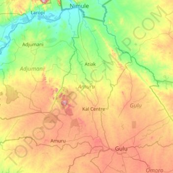
Name: Amuru topographic map, elevation, terrain.
Location: Amuru, Northern Region, Uganda (2.67648 31.36042 3.58125 32.36382)
Average elevation: 893 m
Minimum elevation: 613 m
Maximum elevation: 1,496 m
Make a donation
Gear up for your next adventure:
As an Amazon Associate, this site earns from qualifying purchases at no extra cost to you.
Other topographic maps
Click on a map to view its topography, its elevation and its terrain.
Make a donation
Gear up for your next adventure:
As an Amazon Associate, this site earns from qualifying purchases at no extra cost to you.
Make a donation
Gear up for your next adventure:
As an Amazon Associate, this site earns from qualifying purchases at no extra cost to you.
Nansana
Nansana is located on the main highway between Kampala and Hoima, the Kampala-Hoima Road. The town is located approximately 12 kilometres (7 mi), by road, north-west of Kampala, Uganda's capital and largest city. This is approximately 8 kilometres (5 mi), by road, south of Wakiso, the location of the district…
Average elevation: 1,172 m
Make a donation
Gear up for your next adventure:
As an Amazon Associate, this site earns from qualifying purchases at no extra cost to you.