
Make a donation
Gear up for your next adventure:
As an Amazon Associate, this site earns from qualifying purchases at no extra cost to you.
Jinja topographic map
Click on the map to display elevation.
Make a donation
Gear up for your next adventure:
As an Amazon Associate, this site earns from qualifying purchases at no extra cost to you.
Jinja
It sits along the northern shores of Lake Victoria, near the source of the White Nile. The city sits at an average elevation of 1,204 metres (3,950 ft) above sea level.
Make a donation
Gear up for your next adventure:
As an Amazon Associate, this site earns from qualifying purchases at no extra cost to you.
About this map
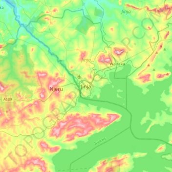
Name: Jinja topographic map, elevation, terrain.
Location: Jinja, Eastern Region, 123, Uganda (0.27530 33.04556 0.59530 33.36556)
Average elevation: 1,170 m
Minimum elevation: 1,069 m
Maximum elevation: 1,367 m
Make a donation
Gear up for your next adventure:
As an Amazon Associate, this site earns from qualifying purchases at no extra cost to you.