Geolocate
👉 Easily get elevation data in JSON, GeoTIFF and KML formats using Elevation API
Thank you for supporting this site ❤️
Make a donation

Gear up for your next adventure:

As an Amazon Associate, this site earns from qualifying purchases at no extra cost to you.

Calhoun topographic map

Click on the map to display elevation.

About this map

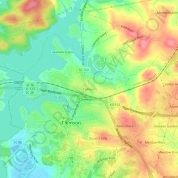
Name: Calhoun topographic map, elevation, terrain.

Location: Calhoun, Clemson, Pickens County, South Carolina, 29361, United States (34.67261 -82.85153 34.71261 -82.81153)

Average elevation: 227 m

Minimum elevation: 188 m

Maximum elevation: 272 m

Other topographic maps

Click on a map to view its topography, its elevation and its terrain.

Gear up for your next adventure:

🎽Thermal Base Layers - Essential moisture management for cold weather
🖼️Vintage Irish Map Prints - Decorative wall art for map lovers and geographers
🛸Lightweight Camera Drones - Capture stunning aerial topographic views of the landscape
🪵Fire Starters & Tools - Tools to start fire in wet conditions
🧦Merino Wool Socks - Moisture-wicking and blister-preventing trail socks

As an Amazon Associate, this site earns from qualifying purchases at no extra cost to you.