
Make a donation
Gear up for your next adventure:
As an Amazon Associate, this site earns from qualifying purchases at no extra cost to you.
Parker topographic map
Click on the map to display elevation.
Make a donation
Gear up for your next adventure:
As an Amazon Associate, this site earns from qualifying purchases at no extra cost to you.
Parker
Parker is located in northeastern Douglas County. Its northernmost border follows the Arapahoe County line, and the city of Aurora touches the town's northeast border. The center of Parker is 23 miles (37 km) southeast of downtown Denver. Castle Rock, the Douglas County seat, is 15 miles (24 km) to the southwest. Unincorporated communities that border Parker are Dove Valley to the northwest, Stonegate to the west, and The Pinery to the south. Parker sits at an elevation of 5,900 feet above sea level.
Make a donation
Gear up for your next adventure:
As an Amazon Associate, this site earns from qualifying purchases at no extra cost to you.
About this map
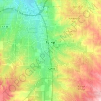
Name: Parker topographic map, elevation, terrain.
Location: Parker, Douglas County, Colorado, 80134, United States (39.45309 -104.82166 39.56596 -104.70849)
Average elevation: 1,845 m
Minimum elevation: 1,740 m
Maximum elevation: 1,997 m
Make a donation
Gear up for your next adventure:
As an Amazon Associate, this site earns from qualifying purchases at no extra cost to you.
Other topographic maps
Click on a map to view its topography, its elevation and its terrain.