
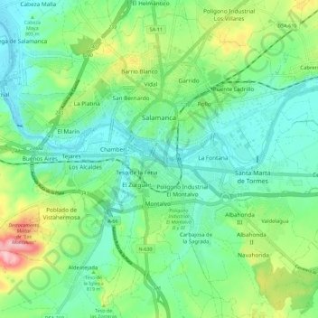
Salamanca topographic map
Interactive map
Click on the map to display elevation.
About this map
Name: Salamanca topographic map, elevation, terrain.
Location: Salamanca, Castile and León, Spain (40.91463 -5.73580 40.99319 -5.62262)
Average elevation: 812 m
Minimum elevation: 763 m
Maximum elevation: 935 m
With an altitude of over 800 meters, Salamanca has a warm-summer Mediterranean climate (Csb) according to the Köppen climate classification, with some cold semi-arid climate (BSk) climatic influences, resulting in large diurnal temperature variations, with hot summers and chilly winters, and nearly-semi-arid levels of precipitation. Salamanca does not have a real wet season. Most of the precipitation falls outside of the summer, with upticks at the end of the spring and during the winter; all winters have snow during few days per year, although heavy snowfalls are uncommon, but not unheard of. The city averages around 7 days of snowy days per year, morning frost during winters is very common, as on a normal year, Salamanca has on average 76 days with low temperatures below freezing.
Other topographic maps
Click on a map to view its topography, its elevation and its terrain.
San Juan del Monte
San Juan del Monte, Burgos, Castile and León, Spain
Average elevation: 872 m
Mambrillas de Lara
Mambrillas de Lara, Burgos, Castile and León, 09642, Spain, Peñalara
Average elevation: 1,071 m
Morales
Spain > Castile and León > Berlanga de Duero
Morales, Berlanga de Duero, Soria, Castile and León, Spain
Average elevation: 920 m
Morales de Toro
Morales de Toro, Zamora, Castile and León, Spain
Average elevation: 701 m
Arturo Eyries
Spain > Castile and León > Valladolid
Arturo Eyries, Valladolid, Castile and León, Spain
Average elevation: 703 m
Salas de Los Barrios
Spain > Castile and León > El Bierzo > Ponferrada > Salas de Los Barrios
Salas de Los Barrios, Ponferrada, El Bierzo, León, Castile and León, 24414, Spain
Average elevation: 724 m
Rágama
Spain > Castile and León > Rágama
Rágama, Salamanca, Castile and León, Spain
Average elevation: 845 m
San Justo
Spain > Castile and León > San Justo
San Justo, Galende, Castile and León, Spain
Average elevation: 1,332 m
Riaño
Spain > Castile and León > Riaño
Riaño, Castile and León, 24900, Spain
Average elevation: 1,140 m
Movilla
Spain > Castile and León > Movilla
Movilla, Llano de Bureba, Miranda de Ebro, Castile and León, 09210, Spain
Average elevation: 668 m
Riaño
Spain > Castile and León > Riaño
Riaño, León, Castile and León, 24900, Spain
Average elevation: 1,313 m
Buenavista
Spain > Castile and León > Buenavista
Buenavista, Guijuelo, Castile and León, 37789, Spain
Average elevation: 936 m
Barruecopardo
Spain > Castile and León > Barruecopardo
Barruecopardo, Comarca de Vitigudino, Salamanca, Castile and León, 37255, Spain
Average elevation: 667 m
Pico Almanzor
Spain > Castile and León > Candeleda
Pico Almanzor, Candeleda, Comarca de Arenas de San Pedro, Ávila, Castile and León, Spain
Average elevation: 2,159 m
Villamanín
Spain > Castile and León > Villamanín
Villamanín, León, Castile and León, Spain
Average elevation: 1,440 m
Atua
Spain > Castile and León > Condado de Treviño
Atua, Condado de Treviño, Ebro, Burgos, Castile and León, Spain
Average elevation: 629 m