
Nowy Targ County topographic map
Interactive map
Click on the map to display elevation.
About this map
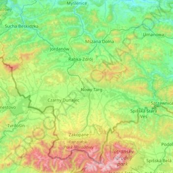
Name: Nowy Targ County topographic map, elevation, terrain.
Location: Nowy Targ County, Lesser Poland Voivodeship, Poland (49.32641 19.52741 49.66112 20.61706)
Average elevation: 757 m
Minimum elevation: 241 m
Maximum elevation: 2,601 m
Other topographic maps
Click on a map to view its topography, its elevation and its terrain.
Libertów
Poland > Lesser Poland Voivodeship > Kraków County
Libertów, gmina Mogilany, Kraków County, Lesser Poland Voivodeship, 30-444, Poland
Average elevation: 270 m
Krakow
Poland > Lesser Poland Voivodeship
Krakow, Lesser Poland Voivodeship, Poland
Average elevation: 263 m
Limanowa
Poland > Lesser Poland Voivodeship > Limanowa
Limanowa, Limanowa County, Lesser Poland Voivodeship, Poland
Average elevation: 490 m
Zakopane
Poland > Lesser Poland Voivodeship > Zakopane
Zakopane, Tatra County, Lesser Poland Voivodeship, Poland
Average elevation: 1,180 m
Nowy Targ
Poland > Lesser Poland Voivodeship > Nowy Targ
Nowy Targ, powiat nowotarski, Lesser Poland Voivodeship, Poland
Average elevation: 679 m