
Make a donation
Gear up for your next adventure:
As an Amazon Associate, this site earns from qualifying purchases at no extra cost to you.
Indonesia topographic map
Click on the map to display elevation.
Make a donation
Gear up for your next adventure:
As an Amazon Associate, this site earns from qualifying purchases at no extra cost to you.
Indonesia
Indonesia's topography is as varied as its expansive archipelago, marked by rugged mountain ranges, volcanic activity, and vast lowland plains. The majority of its major islands are mountainous, with some of the highest peaks rising above 16,000 feet (4,877 meters), such as Puncak Jaya in Papua. These mountains, part of the Pacific Ring of Fire, are often volcanic, contributing to frequent eruptions and seismic activity. The western islands, like Sumatra and Java, are particularly mountainous with steep, densely forested landscapes, while the eastern regions, such as Papua, feature towering ranges and glacial peaks. Between these highlands, Indonesia's lowlands primarily consist of coastal plains and river valleys, which are especially prominent on islands like Borneo and Sumatra. This diversity in terrain—ranging from volcanic peaks to deep sea trenches—creates a complex and dynamic landscape, fostering a unique biodiversity and a range of ecosystems across the country.
Make a donation
Gear up for your next adventure:
As an Amazon Associate, this site earns from qualifying purchases at no extra cost to you.
About this map
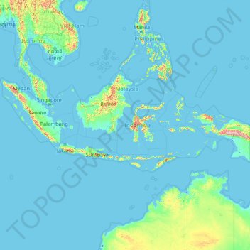
Name: Indonesia topographic map, elevation, terrain.
Location: Indonesia (-11.20857 94.77171 6.27445 141.01944)
Average elevation: 81 m
Minimum elevation: -3 m
Maximum elevation: 4,198 m
Make a donation
Gear up for your next adventure:
As an Amazon Associate, this site earns from qualifying purchases at no extra cost to you.
Other topographic maps
Click on a map to view its topography, its elevation and its terrain.
Tbilisi
Most of the raions are named after historic quarters of the city. The citizens of Tbilisi widely recognise an informal system of smaller historic neighbourhoods. Such neighbourhoods are several, however, constituting a kind of hierarchy, because most of them have lost their distinctive topographic limits. The…
Average elevation: 713 m
Dandenong Ranges
Australia > Victoria > Melbourne
The topography consists of a series of ridges dissected by deeply cut streams. Sheltered gullies in the south of the range are home to temperate rain forest, fern gullies and Mountain Ash forest Eucalyptus regnans, whereas the drier ridges and exposed northern slopes are covered by dry sclerophyll forest of…
Average elevation: 456 m
Make a donation
Gear up for your next adventure:
As an Amazon Associate, this site earns from qualifying purchases at no extra cost to you.
Make a donation
Gear up for your next adventure:
As an Amazon Associate, this site earns from qualifying purchases at no extra cost to you.
Make a donation
Gear up for your next adventure:
As an Amazon Associate, this site earns from qualifying purchases at no extra cost to you.
Make a donation
Gear up for your next adventure:
As an Amazon Associate, this site earns from qualifying purchases at no extra cost to you.
Make a donation
Gear up for your next adventure:
As an Amazon Associate, this site earns from qualifying purchases at no extra cost to you.
Make a donation
Gear up for your next adventure:
As an Amazon Associate, this site earns from qualifying purchases at no extra cost to you.
Make a donation
Gear up for your next adventure:
As an Amazon Associate, this site earns from qualifying purchases at no extra cost to you.
Make a donation
Gear up for your next adventure:
As an Amazon Associate, this site earns from qualifying purchases at no extra cost to you.
Make a donation
Gear up for your next adventure:
As an Amazon Associate, this site earns from qualifying purchases at no extra cost to you.
Carrauntoohil
Carrauntoohil is the highest mountain in Ireland on all classification scales. It is the 133rd-highest mountain, and 4th most prominent mountain, in Britain and Ireland, on the Simms classification. Carrauntoohil is regarded by the Scottish Mountaineering Club (SMC) as one of 34 Furths, which are defined as…
Average elevation: 644 m
Make a donation
Gear up for your next adventure:
As an Amazon Associate, this site earns from qualifying purchases at no extra cost to you.
Make a donation
Gear up for your next adventure:
As an Amazon Associate, this site earns from qualifying purchases at no extra cost to you.
Make a donation
Gear up for your next adventure:
As an Amazon Associate, this site earns from qualifying purchases at no extra cost to you.
Swords
Ireland > County Dublin > Swords
The medieval town developed in a linear pattern along Main Street, in a roughly north-south direction. Swords has one of the best examples of this settlement pattern in the Dublin region. The round tower, 26m in height, is also an indicator of early Christian settlement. The Irish high king Brian Boru is said…
Average elevation: 28 m
Make a donation
Gear up for your next adventure:
As an Amazon Associate, this site earns from qualifying purchases at no extra cost to you.
Make a donation
Gear up for your next adventure:
As an Amazon Associate, this site earns from qualifying purchases at no extra cost to you.
Make a donation
Gear up for your next adventure:
As an Amazon Associate, this site earns from qualifying purchases at no extra cost to you.
Make a donation
Gear up for your next adventure:
As an Amazon Associate, this site earns from qualifying purchases at no extra cost to you.
Make a donation
Gear up for your next adventure:
As an Amazon Associate, this site earns from qualifying purchases at no extra cost to you.
Great Skellig
The island is of special interest to archaeologists, as the monastic settlement is in unusually good condition. The monastery on the northern peak is situated at an elevation of 170 to 180 m (550 to 600 ft), Christ's Saddle at 129 m (422 ft), and the flagstaff area are 37 m (120 ft) above sea level. The…
Average elevation: 1 m
Make a donation
Gear up for your next adventure:
As an Amazon Associate, this site earns from qualifying purchases at no extra cost to you.
Lambay Island
Lambay Island is the largest island off the east coast of Ireland. It covers about 2.5 km2 (0.97 sq mi). The highest point – a hill known as Knockbane – rises to 126 m (413 ft). The island's high ground lies to the east and aside from Knockbane includes Heath Hill and Tinian Hill, and in the extreme…
Average elevation: 14 m
Make a donation
Gear up for your next adventure:
As an Amazon Associate, this site earns from qualifying purchases at no extra cost to you.
Make a donation
Gear up for your next adventure:
As an Amazon Associate, this site earns from qualifying purchases at no extra cost to you.
Make a donation
Gear up for your next adventure:
As an Amazon Associate, this site earns from qualifying purchases at no extra cost to you.
Make a donation
Gear up for your next adventure:
As an Amazon Associate, this site earns from qualifying purchases at no extra cost to you.
Make a donation
Gear up for your next adventure:
As an Amazon Associate, this site earns from qualifying purchases at no extra cost to you.
Lugnaquilla
Lugnaquilla is the 432nd-highest and 21st most prominent mountain in Britain and Ireland, on the Simms classification. It is regarded by the Scottish Mountaineering Club (SMC) as one of 34 Furths, which is a mountain above 3,000 ft (914 m) in elevation, and meets the other SMC criteria for a Munro (e.g.…
Average elevation: 696 m
Make a donation
Gear up for your next adventure:
As an Amazon Associate, this site earns from qualifying purchases at no extra cost to you.
Knocknapeasta
It is the 231st-highest mountain in Britain and Ireland on the Simm classification. Cnoc na Péiste is regarded by the Scottish Mountaineering Club ("SMC") as one of 34 Furths, which is a mountain above 3,000 ft (914.4 m) in elevation, and meets the other SMC criteria for a Munro (e.g. "sufficient…
Average elevation: 579 m
Caher
Caher is the 200th–highest mountain in Britain and Ireland on the Simm classification. Caher is regarded by the Scottish Mountaineering Club ("SMC") as one of 34 Furths, which is a mountain above 3,000 ft (914.4 m) in elevation, and meets the other SMC criteria for a Munro (e.g. "sufficient separation"), but…
Average elevation: 617 m
Beenkeragh
Beenkeragh is the second-highest peak in Ireland, on both the Arderin and Vandeleur-Lynam lists. It is the 179th-highest mountain in Britain and Ireland on the Simm classification. Beenkeragh is regarded by the Scottish Mountaineering Club ("SMC") as one of 34 Furths, which is a mountain above 3,000 ft (914 m)…
Average elevation: 654 m
Make a donation
Gear up for your next adventure:
As an Amazon Associate, this site earns from qualifying purchases at no extra cost to you.