
Make a donation
Gear up for your next adventure:
As an Amazon Associate, this site earns from qualifying purchases at no extra cost to you.
Ephrata topographic map
Click on the map to display elevation.
Make a donation
Gear up for your next adventure:
As an Amazon Associate, this site earns from qualifying purchases at no extra cost to you.
About this map
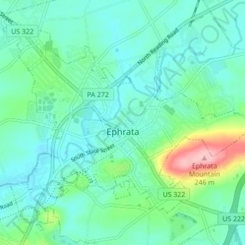
Name: Ephrata topographic map, elevation, terrain.
Average elevation: 129 m
Minimum elevation: 97 m
Maximum elevation: 247 m
Make a donation
Gear up for your next adventure:
As an Amazon Associate, this site earns from qualifying purchases at no extra cost to you.
Other topographic maps
Click on a map to view its topography, its elevation and its terrain.
Reinholds
United States > Pennsylvania > Lancaster County > West Cocalico Township
Average elevation: 159 m
Welsh Mountain Nature Preserve
United States > Pennsylvania > Lancaster County > East Earl Township
Average elevation: 294 m
Intercourse
United States > Pennsylvania > Lancaster County > Leacock Township
Average elevation: 127 m
Make a donation
Gear up for your next adventure:
As an Amazon Associate, this site earns from qualifying purchases at no extra cost to you.
Holland Heights
United States > Pennsylvania > Lancaster County > East Lampeter Township
Average elevation: 101 m
Make a donation
Gear up for your next adventure:
As an Amazon Associate, this site earns from qualifying purchases at no extra cost to you.
Stevens
United States > Pennsylvania > Lancaster County > West Cocalico Township
Average elevation: 121 m
Smithville
United States > Pennsylvania > Lancaster County > Providence Township
Average elevation: 140 m
Make a donation
Gear up for your next adventure:
As an Amazon Associate, this site earns from qualifying purchases at no extra cost to you.
Drumore Center
United States > Pennsylvania > Lancaster County > Drumore Township
Average elevation: 175 m
Brownstown
United States > Pennsylvania > Lancaster County > West Earl Township
Average elevation: 102 m
Hopeland
United States > Pennsylvania > Lancaster County > Clay Township > Clay
Average elevation: 155 m
Make a donation
Gear up for your next adventure:
As an Amazon Associate, this site earns from qualifying purchases at no extra cost to you.
Welsh Mountain
United States > Pennsylvania > Lancaster County > Caernarvon Township
Average elevation: 233 m
Brooklawn
United States > Pennsylvania > Lancaster County > Manheim Township > Neffsville
Average elevation: 116 m
Baumgardner
United States > Pennsylvania > Lancaster County > Pequea Township
Average elevation: 126 m
Coopersville
United States > Pennsylvania > Lancaster County > Sadsbury Township
Average elevation: 183 m
Make a donation
Gear up for your next adventure:
As an Amazon Associate, this site earns from qualifying purchases at no extra cost to you.
Chestnut Ridge
United States > Pennsylvania > Lancaster County > Rohrerstown > Chestnut Ridge
Average elevation: 122 m
Churchtown
United States > Pennsylvania > Lancaster County > Caernarvon Township
Average elevation: 163 m
Safe Harbor
United States > Pennsylvania > Lancaster County > Conestoga Township
Average elevation: 103 m
Stevens
United States > Pennsylvania > Lancaster County > West Cocalico Township
Average elevation: 121 m
Make a donation
Gear up for your next adventure:
As an Amazon Associate, this site earns from qualifying purchases at no extra cost to you.
Smithville
United States > Pennsylvania > Lancaster County > Providence Township
Average elevation: 140 m
Greenland
United States > Pennsylvania > Lancaster County > East Lampeter Township
Average elevation: 112 m
Farmdale
United States > Pennsylvania > Lancaster County > West Hempfield Township
Average elevation: 131 m
McGovernsville
United States > Pennsylvania > Lancaster County > East Hempfield Township > Rohrerstown
Average elevation: 109 m
Make a donation
Gear up for your next adventure:
As an Amazon Associate, this site earns from qualifying purchases at no extra cost to you.
Bowling Green
United States > Pennsylvania > Lancaster County > Manor Township
Average elevation: 107 m
Reinholds
United States > Pennsylvania > Lancaster County > West Cocalico Township
Average elevation: 159 m
Make a donation
Gear up for your next adventure:
As an Amazon Associate, this site earns from qualifying purchases at no extra cost to you.