
Make a donation
Gear up for your next adventure:
As an Amazon Associate, this site earns from qualifying purchases at no extra cost to you.
Viseu topographic map
Click on the map to display elevation.
Make a donation
Gear up for your next adventure:
As an Amazon Associate, this site earns from qualifying purchases at no extra cost to you.
Viseu
É envolvida por um sistema montanhoso, constituído a norte pelas serras de Leomil, Montemuro e Lapa, a noroeste a serra do Arado, a sul e sudoeste as serras da Estrela e Lousã, e a oeste a serra que mais diretamente influencia esta área, a do Caramulo. O município caracteriza-se por uma superfície irregular com altitudes compreendidas entre os 400 e os 700 m.
Make a donation
Gear up for your next adventure:
As an Amazon Associate, this site earns from qualifying purchases at no extra cost to you.
About this map
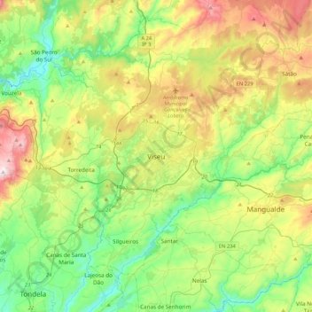
Name: Viseu topographic map, elevation, terrain.
Location: Viseu, 3514-501, Portugal (40.49747 -8.07387 40.81747 -7.75387)
Average elevation: 444 m
Minimum elevation: 145 m
Maximum elevation: 1,034 m
Make a donation
Gear up for your next adventure:
As an Amazon Associate, this site earns from qualifying purchases at no extra cost to you.
Other topographic maps
Click on a map to view its topography, its elevation and its terrain.