
Make a donation
Gear up for your next adventure:
As an Amazon Associate, this site earns from qualifying purchases at no extra cost to you.
Povolide topographic map
Click on the map to display elevation.
Make a donation
Gear up for your next adventure:
As an Amazon Associate, this site earns from qualifying purchases at no extra cost to you.
About this map
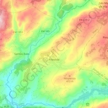
Name: Povolide topographic map, elevation, terrain.
Location: Povolide, Viseu, Portugal (40.63341 -7.83301 40.69066 -7.75898)
Average elevation: 407 m
Minimum elevation: 273 m
Maximum elevation: 575 m
Make a donation
Gear up for your next adventure:
As an Amazon Associate, this site earns from qualifying purchases at no extra cost to you.
Other topographic maps
Click on a map to view its topography, its elevation and its terrain.
Viseu
É envolvida por um sistema montanhoso, constituído a norte pelas serras de Leomil, Montemuro e Lapa, a noroeste a serra do Arado, a sul e sudoeste as serras da Estrela e Lousã, e a oeste a serra que mais diretamente influencia esta área, a do Caramulo. O município caracteriza-se por uma superfície…
Average elevation: 444 m