
Muskogee County topographic map
Interactive map
Click on the map to display elevation.
About this map
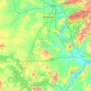
Name: Muskogee County topographic map, elevation, terrain.
Location: Muskogee County, Oklahoma, Stati Uniti d'America (35.26210 -95.76627 35.85766 -95.05057)
Average elevation: 190 m
Minimum elevation: 141 m
Maximum elevation: 328 m
Other topographic maps
Click on a map to view its topography, its elevation and its terrain.
Pryor Creek
Stati Uniti d'America > Oklahoma > Mayes County
Pryor Creek, Mayes County, Oklahoma, Stati Uniti d'America
Average elevation: 190 m
Tulsa
Stati Uniti d'America > Oklahoma > Tulsa
Tulsa, Tulsa County, Oklahoma, Stati Uniti d'America
Average elevation: 221 m
Muskogee
Stati Uniti d'America > Oklahoma > Muskogee
Muskogee, Muskogee County, Oklahoma, Stati Uniti d'America
Average elevation: 176 m