
Thank you for supporting this site ❤️
Make a donation
Make a donation
Gear up for your next adventure:
As an Amazon Associate, this site earns from qualifying purchases at no extra cost to you.
Comines-Warneton topographic map
Click on the map to display elevation.
Thank you for supporting this site ❤️
Make a donation
Make a donation
Gear up for your next adventure:
As an Amazon Associate, this site earns from qualifying purchases at no extra cost to you.
About this map
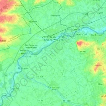
Name: Comines-Warneton topographic map, elevation, terrain.
Location: Comines-Warneton, Tournai-Mouscron, Hainaut, Wallonia, Belgium (50.69235 2.84203 50.81080 3.02984)
Average elevation: 22 m
Minimum elevation: 9 m
Maximum elevation: 61 m
Thank you for supporting this site ❤️
Make a donation
Make a donation
Gear up for your next adventure:
As an Amazon Associate, this site earns from qualifying purchases at no extra cost to you.
Other topographic maps
Click on a map to view its topography, its elevation and its terrain.