
新雪谷町 topographic map
Interactive map
Click on the map to display elevation.
About this map
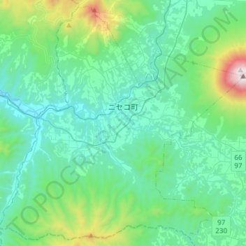
Name: 新雪谷町 topographic map, elevation, terrain.
Location: 新雪谷町, 虻田郡, 後志綜合振興局, 北海道, 日本 (42.70718 140.56232 42.87802 140.80684)
Average elevation: 339 m
Minimum elevation: 24 m
Maximum elevation: 1,854 m
Other topographic maps
Click on a map to view its topography, its elevation and its terrain.